This item has been sold, but you can enter your email address to be notified if another example becomes available.


|
||

|

|
|

|
Stock# 59251
Description
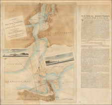
Rare Historical Map of the Niagara River, Published in Niagara Falls, New York.
Large lithographed map of the Niagara River, featuring old portages, battles (many from the War of 1812), trading posts, etc.
The map has an early manuscript note that Fort Niagara was "Surrendered to the United States August 11, 1796."
The map was made by Niagara Falls civil engineer W.C. Johnson for Peter A. Porter, a noteworthy figure in local history, and publisher of the Niagara Falls Gazette from 1880 to 1895.
Provenance
Ex Rochester Historical Society, with their ink stamp on verso and their red-oval inventory sticker on recto in the lower right corner. Sold by them through Cottone Auctions in December 2018.
Condition Description
Slight loss at upper right corner, only affecting the neatline. Some of the old folds lightly worn. Backed on linen. Red oval inventory sticker of the Rochester Historical Society in the lower right corner.

![[Niagara Falls] Cataracte de Niagara](https://storage.googleapis.com/raremaps/img/small/96890.jpg)