


|
||

|

|
|

|
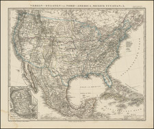
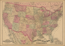
Detailed map of the United States, illustrating the travels of Emmanuel Domenech.
The map illustrates the travels of the Abbe Domenech in red, covering much of the Western United States. The huge Nebraska Territory stretches between Minnesota to Oregon and Washington Territories at the continental divide, and south to Kansas. The large Kansas Territory borders Utah and New Mexico at the Continental Divide and there is no mention of Colorado or of any early towns therein. Utah and New Mexico are both shown in their largest configurations.
The map is filled with details and place names, forts, Indian tribes, the emigrant roads and more. Several exploration routes are shown, including those of Fremont, Marcy, and Kearney
Emmanuel Domenech
Domenech was born at Rochetaillée-sur-Saône, France. In 1846, he left France to be a Catholic missionary in Texas, then rapidly filling up with American and European immigration. He went first to St. Louis, studying English and German, and gathering knowledge of missionary requirements. In 1848, he relocated to the new German settlement of Castroville in Texas. In 1850, he visited Europe and was received by Pope Pius IX, who personally paid for his return to Texas.
He returned to Brownsville, Texas in May 1851, then a haven to raiding bands of Mexicans and Texas Rangers, while outlaws from the border States and lawless discharged soldiers filled the new towns. He remained in Southern Texas until September 1852, largely to recover his health.
When French troops were dispatched to Mexico in 1861 he was selected to accompany the expedition. led by Emperor Maximilian. After returning to France, he devoted his remaining years to European travel, study, and writing, and the exercise of his ecclesiastical functions.
![Gen. Washington [On The Battlefield At Trenton] Engraved by W. Warner from the original picture by Col John Trumbull](https://storage.googleapis.com/raremaps/img/small/103233.jpg)