|
||

|

|
|

|
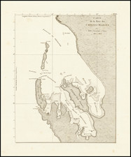
The first English map of Australia, which is derived directly from Thevenot's seminal map of 1663, showing the Dutch discoveries in the region.
Bowen's map is the first English map of New Holland. The map appeared in the revised edition of John Harris' Complete Collection of Voyages. Bowen's map adds the Tropic of Capricorn and two texts: the upper block emphasizes that no assumptions have been made, so white space abounds between New Guinea and Carpentaria, and between the mainland, Tasmania and New Zealand; the lower text starts: It is impossible to conceive a Country that promises fairer from its situation, than this of Terra Australia; no longer incognita, as this map demonstrates…
The map is derived directly from Thevenot's seminal map of 1663, showing the Dutch discoveries in the region done by the VOC. The Continent of Australia, as mentioned in the title, was surveyed by Capt. Abel Tasman.
Abel Janszoon Tasman was a Dutch seafarer, explorer, and merchant, best known for his voyages of 1642 and 1644 in the service of the Dutch East India Company (VOC). He was the first known European explorer to reach the islands of Tasmania and New Zealand and to sight the Fiji islands. During his second voyage to the pacific, he missed the Torres Strait between New Guinea and Australia, continuing his voyage westwards along the north Australian coast. He mapped the north coast of Australia making observations on the land (called New Holland). From the point of view of the Dutch East India Company, Tasman's explorations were a disappointment: he had neither found a promising area for trade nor a useful new shipping route. Although received modestly, the company was upset that Tasman didn't fully explore the lands he found and decided that a more "persistent explorer" should be chosen for any future expeditions.
The text includes reference to 'the best climate in the world', 'according to Coll. Purry'. Purry was a former employee of the Dutch East India Company interested in attracting the Dutch, French, and English to settle in Nuyts' land, to no avail. Only once Capitan Cook confirmed the assertions made by Purry did interest arise about the land.
Emanuel Bowen (1694?-1767) was a British engraver and print seller. He was most well-known for his atlases and county maps. Although he died in poverty, he was widely acknowledged for his expertise and was appointed as mapmaker to both George II of England and Louis XV of France. His business was carried on by his son, Thomas Bowen. He also trained many apprentices, two of whom became prominent mapmakers, Thomas Kitchin and Thomas Jeffreys.
![[Spectacular Set of Wall Maps of the Continents Dedicated to King Charles II of England, &c.]](https://storage.googleapis.com/raremaps/img/small/93614.jpg)
![[Australia] Ins kleine Gebrachte Karte von den Sud-Laendern Zur Historie der Reisen](https://storage.googleapis.com/raremaps/img/small/93880.jpg)