|
||

|

|
|

|
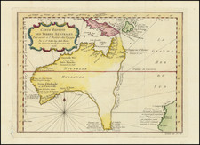
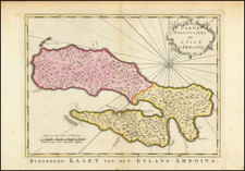
Scarce first state of this decorative map of Southeast Asia and the North Coast of Australia by Cantelli da Vignola and published in Rome by Rossi.
Detailed and highly decorative 17th-century Italian map of northern Australia and the islands of Melanesia and South East Asia, depicting Malaya (Penisola di Malacca), Sumatra, Java, Celebes, Nova Guinea, and Nuova Olanda (Australia). Includes all of Tasman's discoveries in north Australia, but still retains some of the earlier hypothetical provinces associated with the north-west coast (from Marco Polo), Maletur, etc. A clear passage between Cape York and New Guinea with a noted Abrolhos.
Dimensional, decorative cartouche with mermen and cherubs around the title.
Giacomo Giovanni Rossi (1627-1691) was an Italian engraver and printer. He worked in Rome, the heir to an important printing business founded by his father, Giuseppe de Rossi (1570-1639). Giuseppe began the press in 1633 and Giovanni and his brother, Giandomenico (1619-1653) took it over upon his death. The brothers expanded the business and by the mid-seventeenth century it was the best-known printing house in Rome.
For his maps, Giovanni worked with Giacomo Cantelli da Vignola. They produced the Atlas Mercurio Geografico. The first edition is undated, but the second was issued in 1692, a year after Giovanni’s death. The maps were by Cantelli. The firm also published maps based on those of Nicolas Sanson.
Later, the business passed to Lorenzo Filippo (1682-?). By 1738, the firm was known as Calcografia Camerale, then, from 1870 to 1945, as the Regia Calcografica. Today, the firm is still in business and is called Calcografia Nazionale. It operates as a free museum and offers one of the best collections of prints and plates in the world.
![[Southeast Asia, Philippines & India] Nova Delineatio particularis Apostolicarum Peregrinationum noni Indiarum Apostoli in India Orientali](https://storage.googleapis.com/raremaps/img/small/51679.jpg)