This item has been sold, but you can enter your email address to be notified if another example becomes available.


|
||

|

|
|

|
Stock# 59184
Description
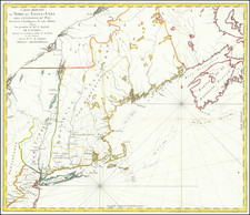
Rare early copy of Patrick McKellar's map of the Siege of Quebec, April 28, 1760.
We believe this copy was created in 1905 by the Canadian National Archives or other branch of the Canadian Government.
The map is based upon an original manuscript map by Patrick McKellar. The original map would appear to be at the Clements Library, University of Michigan.
Patrick McKellar was a very distinguished military engineer. He was with Braddock in his disastrous campaign, he built the forts at Ontario and Oswego, was with Lord Amherst at Louisberg and with Wolfe at Quebec.
Provenance: Rochester Historical Society. Sold by Cottone Auctions in December 2019.
Condition Description
Laid on linen. Includes several library stamps from Rochester Historical Society.
![[ Canada / New France Official Report Regarding Return of Fort Bourbon and Dispute with Hudson Bay Company ] May 27, 1699 Report of Louis II Phélypeaux, Comte de Pontchartrain](https://storage.googleapis.com/raremaps/img/small/100562.jpg)