|
||

|

|
|

|
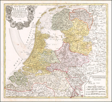
A fine example of John Speed's highly decorative map of the Low Countries.
This attractive map embraces all of the 17 traditional provinces of the Netherlands, including the modern nations of the Netherlands, Belgium and Luxembourg. At the time, the Netherlands was engaged in the Eighty Years War (1568-1648), during which the independent Dutch Republic (comprising the northern provinces) was engaged in a long battle against Spain, who controlled the southern provinces.
The borders of the map are adorned with vignettes including views of the cities of Amsterdam, Antwerp, Ghent, Middelburg, Groeningen, Zutphen, Utrectht and Atrecht, as well as images of various inhabitants of the Low Countries in costume.
John Speed (1552-1629) was a towering figure in the history of British cartography. The present map is from Speed's Prospect Of the Most Famous Parts of the World (London, 1627), which was the first world atlas produced by an Englishman. Speed relied on the latest Dutch sources in composing the map.
John Speed (1551 or '52 - 28 July 1629) was the best known English mapmaker of the Stuart period. Speed came to mapmaking late in life, producing his first maps in the 1590s and entering the trade in earnest when he was almost 60 years old.
John Speed's fame, which continues to this day, lies with two atlases, The Theatre of the Empire of Great Britaine (first published 1612), and the Prospect of the Most Famous Parts of the World (1627). While The Theatre ... started as solely a county atlas, it grew into an impressive world atlas with the inclusion of the Prospect in 1627. The plates for the atlas passed through many hands in the 17th century, and the book finally reached its apotheosis in 1676 when it was published by Thomas Bassett and Richard Chiswell, with a number of important maps added for the first time.
![Sneecha. . . [and] Doccum. [and] Sloten [and] Ylstae](https://storage.googleapis.com/raremaps/img/small/89300.jpg)
![Ducatus Iuliacensis, Cliviensis, Montensis: et Comitatus Marciae et Rapens-Bergae, finitimaeque eis Regiones [The Duchy of Jülich, Kleve, and Berg, and the Counties of Mark and Ravenstein, and the neighboring regions.]](https://storage.googleapis.com/raremaps/img/small/75285.jpg)