|
||

|

|
|

|
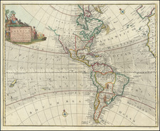
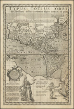
First State of Pierre Du Val's Wall Map of America & The Pacific Ocean
A magnificent, rare seventeenth century wall map of the Western Hemisphere, showing California as an Island and all five Great Lakes, in old outline hand-color.
The maps appeared as four sheets in Du Val's very scarce and highly sought after Cartes Geographiques, his only folio atlas. This is the second state of the map, updated by Du Val's widow Marie Desmaretz, to reflect his death in September 1688.
Northeast
The map is an expanded version of Du Val's 1655 single sheet map. Du Val has replaced New Amsterdam with New York, reflecting the transfer of power from Dutch to English stipulated in the 1667 Treaty of Breda. He has failed to amend the Nouvelle Suede (New Sweden), which had ceased to exist by this time. Further inland, Du Val shows all five Great Lakes, however the boundaries of Lakes Superior and Michigan ("Lac des Puans") are left undetermined.
Southeast
Du Val's purpose in his representation of the American Southeast is quite clear: he advances France's extremely weak claim to the Carolinas, which is labeled "Floride Françoise." But "Charles-Fort," the abortive French settlement on Port Royal Sound (which Du Val shows), had not been relevant since the 1560s. Furthermore, he ignores the permanent English presence in Carolina, established at the mouth Chowan and Roanoke Rivers in 1653, although he shows it in Virginia. Most of the American Southeast is shown as a part of the great Spanish territory of "Floride," which extends north into the Carolinas.
California
As with other mid-seventeenth century maps of the Americas, California is rendered as an island. Du Val's particular California configuration is taken from the Luke Foxe form introduced on a map in 1664. The rest of the American Southwest is rendered with some detail, and the usual speculative inclusions, such as the mythical land of "Quivira" and "Anian". In the Southwest, Du Val labels several Apaches: "Apaches de Navaio", "Apaches de Xila", "Apaches de Perillo", and "Apaches Vaqueros". The Rio del Nort is shown with its source in a large and fictional "lac de Conibas", emptying into the Gulf of California.
North West Passage
This map seems to have been intended as a rhetorical device promoting the idea of a discovered Northwest Passage. Duval makes the case clearly by stating that "On croit qu'en cet endroit il y a communication entre les Mers de Nort et de Sud." that is: "It is believed that this strait communicates between the Seas of the North and the South." Supporting this notion, the map features the track of a supposed 1665 voyage that headed through the Davis and Hudson's Straits.
Pacific
In the South Pacific, Du Val charts the track of Jacob Le Maire on his circumnavigation of 1615-16. New Zealand is shown as a large northern promontory of the "Terre de Quir" and the great southern continent "Terres Ant-Arctiques." Along that landmass's northern coast are "Isles de la Terre Australe reconnues l'an 1576 par Fernandes Gallego." Galleon routes between Mexico and the Philippines are depicted. A large "Terre de Iesso al Eso" is situated off the northwest coast of California.
Each of the four sheets is separately titled, as follows:
-
[upper left] "Le Nouveau Mexique et La Terre de Jesso"
-
[upper right] "La Mer de Nort ou sont La Nle. France, La Floride [etc.]"
-
[lower left] "La Mer de Sud dit autrement Mer Pacifique"
-
[lower right] "Le Perou, Le Chili, La Magellanique, La Plata, et Le Bresil"
The 1679 first state of the map includes the imprint: "Chez l'Auteur l'Isle du Palais/ Sur le Quay de l'Orloge proche le coin de / la rue de Harley"
The circa 1688 second state has a modified imprint: "Chez Melle Du Val. Fille de l'Auteur/ Sur le Quay de l'Orloge pro che le coin de/ la rue de Harley a l'ancien Buis." The imprints on the other three sheets are unaltered.
Rarity
Burden locates only one copy of the first state of the map in a private American collection. He locates institutional copies at the Clements, Harvard, Library of Congress, Newberry Library and Bibliotheque Nationale.
Pierre Duval (1618-1683) was a French geographer, cartographer, and publisher who worked in Abbeville and Paris during the seventeenth century. He was born in the former city, in northeast France, before moving to Paris. Duval was the nephew of the famous cartographer Nicolas Sanson, from whom he learned the mapmaker's art and skills. Both men worked at the royal court, having followed the royal request for artists to relocate to Paris. In addition to numerous maps and atlases, Du Val's opus also includes geography texts. He held the title of geographe ordinaire du roi from 1650 and died in 1683, when his wife and daughters took over his business.
![Oceani Occidentalis Seu Terrae Novae Tabula [The Admiral's Map]](https://storage.googleapis.com/raremaps/img/small/102935.jpg)