|
||

|

|
|

|
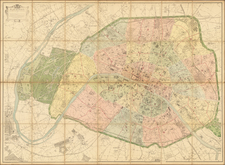
Striking 2-sheet plan of Paris, from the era of Louis XV.
This highly detailed plan of Paris shows streets, buildings, parks, waterways, gardens and other fine details of Paris in the middle of the 18th Century.
The map provides a detailed look at Paris, prior to the redesign of the City under Hausmann, locating many of the most important monuments, bridges and other sites.
Includes a compass rose at the top right, along with explanatory text and a key.
Nicholas de Fer (1646-1720) was the son of a map seller, Antoine de Fer, and grew to be one of the most well-known mapmakers in France in the seventeenth century. He was apprenticed at twelve years old to Louis Spirinx, an engraver. When his father died in 1673, Nicholas helped his mother run the business until 1687, when he became the sole proprietor.
His earliest known work is a map of the Canal of Languedoc in 1669, while some of his earliest engravings are in the revised edition of Methode pour Apprendre Facilement la Geographie (1685). In 1697, he published his first world atlas. Perhaps his most famous map is his wall map of America, published in 1698, with its celebrated beaver scene (engraved by Hendrick van Loon, designed by Nicolas Guerard). After his death in 1720, the business passed to his sons-in-law, Guillaume Danet and Jacques-Francois Benard.
![[ Paris ] Vue generale des Palais De L'Exposition Universelle De 1878 . . .](https://storage.googleapis.com/raremaps/img/small/74482.jpg)
![[ Saint-Denis ] Pourtraict de la Ville de Sainct Denis en France](https://storage.googleapis.com/raremaps/img/small/74991.jpg)
![[ Paris - Place du Roi de Rome - Place de Trocadero ]](https://storage.googleapis.com/raremaps/img/small/90032.jpg)