|
||

|

|
|

|
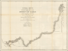
First Map of the Battle of Portobelo with Contemporary Manuscript Annotations
Rare and highly influential plan of Portobelo, Panama based upon the sketch of Phillip Durrell, then a Lieutenant in the British Navy, and brought to London by Captain James Rentone. The plan shows the layout of the Battle of Portobelo, a major early clash in the War of Jenkins Ear and one of the most important British victories in the conflict. Published in March 1740, just as news of the battle reached Britain, this is most likely the first map showing the fight.
Exceptionally, this example has been augmented with contemporary manuscript additions which identify the names of the British ships and some of central British officers who led the assault on Portobelo’s defenses. This dedication to detail shows the fervor such naval battles inspired in those who followed news of them closely.
Another sign of the popularity of the plan is that it there is a second, newly engraved sister plan also produced by Harding & Toms. It seems that the plan proved so popular that the plate quickly wore out from being pressed. A second plate was needed, which Toms engraved with subtle differences which are outlined below. There is also a reduced-size version published in Latin and German in Nuremberg by Homann Heirs.
The plan provides a highly detailed treatment of the most highly-prized Spanish harbor on the Central American coastline. It shows the location of the town of Portobelo and its fortifications, the Iron Castle, Castle de Gloria, and Fort St. Jeronimo, which together guarded both sides of the harbor. The plan also shows soundings, the locations of the rivers which fed the harbor, and detailed, if somewhat stylized, topographical details.
Oriented with southeast at the top, the plan shows Vernon's five-ship attack force entering the harbor with a sixth ship remaining outside for protection. The key at the bottom identifies each of the ships, along with some commanding officers and other points of interest.
Portobelo, Panama
Durrell's plan is one of the most detailed and influential plans of this highly important trading center. Ironically, today Portobelo is a small town with just the ruins of the fort to remind visitors of a time when it was a busy, and hotly contested, port. The site that would become Portobelo was visited by several early conquistadores, including Christopher Columbus, but it was not settled until the end of the sixteenth century.
In 1586, the engineer Juan Bautista Antonelli began to fortify the natural harbor, in order to make it a protected outpost of the Spanish empire. He suggested the abandonment of the nearby settlement of Nombre del Dios in favor of the more easily-defensible Portobelo. This process was accelerated when Francis Drake attacked Nombre de Dios in 1596, causing the settlers to flee. This was actually Drake’s second sacking of Nombre de Dios, the first had been in 1573. A fire, also in 1596, convinced the merchants and their families to develop Portobelo instead.
The city of San Felipe de Portobelo was officially founded in 1597. Although defensible, Portobelo proved a tempting target for privateers, pirates, and navies in opposition to Spain. In 1602, Captain William Parker, a pirate, attacked, followed by Henry Morgan in 1671, who caused significant damage. Portobelo was again harassed, and again by English sailors of dubious reputation, in 1679, when a group including Bartholomew Sharp and the pirate-authors William Dampier and Lionel Wafer came to the harbor. The focus on Portobelo was justified, as the town was the staging place for Spanish silver to be brought from Panama to Havana. Finally, and most famously, Vice-Admiral Edward Vernon bombarded the town in 1739—the subject of this plan.
Vernon, the War of Jenkins Ear, and the Battle of Portobelo
The Battle of Portobelo was a consequential moment in a war that would eventually involve most of Europe and many of the European empires’ colonies around the world. For decades, tension had been mounting between Spanish and British ships in the Caribbean. The British wanted access to Spanish ports, yet the Spanish operated a closed policy with regard to its colonial trade. On the edges of empire, however, illegal trade was the norm and one was only in trouble if one was caught. To counter the practice, Spain created the dreaded guardacostas, or coast guards, who were empowered to seize vessels found to be participating in illicit commerce. Additionally, the Spanish and the British disagreed over the precise boundaries of their North American holdings, particularly in Florida and the southeast.
On April 9, 1731, Captain Robert Jenkins, a British captain, watched as his ship was boarded by guardacostas desiring to inspect his cargo. The Spanish soldiers roughed up the crew, made a mess of the ship, and, as Jenkins claimed, cut off his ear. The captain sailed back to England, where his ear became but one example of Spanish incursions on British liberties, or so the impassioned press would have readers believe. The public cried out for revenge, and the government, faced with a powerful opposition and angry merchants, chose to go to war in October 1739.
The war was no great triumph for Britain, except for one shining moment—the attack on Portobelo by Vice-Admiral Edward Vernon (1684-1757). Vernon was the son of a Westminster bureaucrat and went to sea at age 16. A favorite of Admiral Sir Cloudesley Shovell, Vernon improved from fifth to third lieutenant on the admiral’s flagship, the most important ship in the British fleet. He gained his first command in 1706, and he commanded ships mainly in the Mediterranean, the Caribbean, and the Baltic. He joined Parliament as the representative for Penryn, Cornwall in 1722, starting a fiery political career.
Vernon was voted out in 1734 and for several peacetime years he also had no ship to command. In December 1738, he sought out the Admiralty in light of the impending conflict. First Lord of the Admiralty Sir Charles Wager, to whom this plan is dedicated, gave Vernon command of the West Indies fleet, as no other senior officer wanted the post. It came with a promotion to vice-admiral of the blue.
Vernon arrived in Jamaica in October 1739. He had no set plan of attack, only a desire to best the Spanish in the region. Havana was too risky a target, so Vernon settled instead on Portobelo, which he called “the only mart for all the Wealth of Peru to come to Europe” (Vernon to Newcastle, 31 Oct 1739, TNA: PRO, SP 42/85, f. 31). He sailed for Panama on November 5 and attacked on November 20.
Vernon had previously bragged that he could take the fortified town with only six ships, which is precisely the size of the squadron he commanded, as shown on this plan. Due to the prevailing winds, Vernon concentrated his attack on the fort labeled “Iron Castle” here. Tenders, labeled as key item “I”, ferried marines ashore to attack the fort and stop the Spanish soldiers, who were fleeing. Vernon then began to focus on the other side of the harbor, nearer the settlement. The Spanish asked for terms of surrender early on November 21.
The British occupied the town for three weeks, destroying the fortifications and opening it to British traders. They gained a Spanish snow, most likely the one which delivered Captain Rentone, as explained in key item “L” and two guardacostas vessels, key item “K.” They lost only three men, with seven injured.
Aftermath: the fates of the protagonists and mapmakers
The engagement took only one day and, when he attacked, Vernon still did not know that Britain had already declared war on Spain. News of his victory reached London in March 1740 and it elated a public who expected a quick victory in the latest war. This plan was published March 27, 1740 and it is most likely the first depiction available of the battle.
The capture of Portobelo was received as a popular triumph throughout the British empire. The name Portobelo was often used as a commemorative honor, such as with the Portobelo Road in London, the Portobelo district of Edinburgh, and Porto Bello in Virginia.
Admiral Vernon became a hero. His name was also used in an act of commemoration and veneration, most famously with Mount Vernon, the estate of George Washington. His image, and that of the battle, was emblazoned on medals, ceramics, prints, and fabrics. As the war dragged on and became part of the larger conflict surrounding the Austrian succession, Vernon’s victory remained one of the only bright spots available to a weary British public.
Vernon returned to England after a disastrous campaign in the Caribbean in 1741 with his popularity untarnished. He had been elected a Member of Parliament for three constituencies; he chose to represent Ipswich and held this position until his death. Now without a command, even though the war continued, Vernon became an outspoken critic of the Royal Navy. He did return to command later, but his criticisms eventually saw him struck from the flag list. He continued to be active in politics and died in 1757.
Admiral Vernon would later commission paintings of the battle. One of the paintings, “The bombardment of Portobello,” attributed to Samuel Scott, shows a layout of the harbor. It is assumed that this geography was based on diagrams of the harbor drawn by Captain James Rentone and Captain Phillip Durrell of the Burford, the ship is identified as "E" in the present plan.
Rentone is identified in the title as the person who delivered the manuscript sketch, by Durell, to London. Durell (1707-1766) would reach the rank of vice-admiral, with noteworthy commands in the Battle of Minorca (1756) and the Siege of Quebec (1758). Rentone, however, was not so lucky. A letter from his wife to the Duke of Newcastle in 1748 (BL Add MS 32717, f. 564) reveals that James Rentone, captain of the Strafford—incidentally, one of the ships involved in the attack on Portobelo, key item “G”—had died at the Battle of Saint-Louis-du-Sud, in Saint Domingue. It was one of the final battles of the war.
Aftermath: second-plate engraving and reproduction
This plan also has an intriguing afterlife. It was originally engraved by W. H. Toms and published by Harding & Toms in London in 1740 for only one shilling. It was intended as an affordable memento for those wishing to celebrate and learn more about the battle. The momento proved so popular the plate seems to have worn out, necessitating the engraving of a new plate that is subtly different. The plate is slightly smaller and tidier in its details, as the following census reveals:
Harding & Toms:
Slightly larger
P separated, in three lines
Scale title bigger, scale bar farther down
March THE 27th 1740
Third line of key smaller than previous two
Trees slightly different
Fewer trees around governor’s plantation, titled Gov/rs Plantation
Rose in compass rose finer
Small details in ships different, see especially O, which is inferior
St. Jeronimo Castle label slightly lower
“This Plan” farther from top of title box
“I do assure…” line is left aligned
Key item F, The Hampton Court
Key item P, use of the instead of ye
Second plate example:
Slightly smaller
P integrated, NB in top right of key, third line only slightly smaller
Scale moved up to accommodate extra text below
March 27th 1740
Trees slightly different
More trees around governor’s plantation, titled Govern/rs Plantation
Rose in compass rose squished
Small details in ships different, see especially O, which is finer
St. Jeronimo Castle label slightly higher
“This Plan” closer to top of title box
“I do assure…” line is justified
Key item F, Commodore Brown’s Ship ye Hampton Court
Key item P, use of ye instead of the
Rarity
This Harding & Toms map is rare on the market, most recently offered by Sotheby’s on December 2, 1999 (Lot 187) and by Old World Auctions in 2014. The manuscript additions on this example make it unique and even more historically significant, a fine addition to any collection of Central American, naval, or battle maps.

![(Colombia and Panama) Quarta Hoja que Comprehende las Costas de la Provincia de Cartagena, Golfo Del Darien y Provincio de Porto Velo con el Golfo de Panama y Archipelago de las Perlas. Madrid Año 1817. [Fourth Sheet that Covers the Coasts of the Province of Cartagena, Gulf of Darien and Province of Porto Bello with the Gulf of Panama and Archipelago of the Pearls. Madrid, Year 1817.]](https://storage.googleapis.com/raremaps/img/small/95581.jpg)