


|
||

|

|
|

|
Tianwen tu Star Chart (1247)-- Only the Second-Known Example of a Rubbing Outside of Asia
Extremely rare rubbing of the important Tianwen tu [A Map of the Stars] star chart, originally made in ca. 1190 by the polymath Huang Shang 黃裳. It is accompanied by a rubbin of the Dili Tu [Geographic Map of China] stone map. These are two of the earliest surviving cartographic materials made in China in the Common Era.
Unfortunately, the original map of China and the star chart do not survive. However, a half century after they were made, in 1247, Wang Zhiyuan 王致遠 engraved the works on stone stelae. This is one of the few rubbings taken from the stones and is an extreme rarity seldom seen on the market.
Learn more about the pair and their context here.
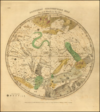
The Tianwen tu star chart
Also known as the Sooochow (Suzhou) Planisphere, this chart depicts a sky that shows constellations from the north celestial pole to 55 degrees south. A central circle represents the north celestial pole (at center) to roughly 35 degrees north. It contains the circumpolar constellations.
The lines radiating from the central circle are the 28 xiu, or mansions, which make up the Chinese constellations system. They are similar to the Western Zodiac system, although they represent the movement of the moon during a sidereal month and not the Sun in a tropical year, as the Zodac does. The 28 mansions are divided into four regions, which are identified with an animal (Azure Dragon, Black Tortoise, White Tiger, and Vermilion Bird). Each mansion line corresponds to the longitude along the ecliptic that the Moon crosses as it orbits the Earth.
Hundreds of constellations are shown with snaking lines and characters. The text below explains that 1565 stars are known to astronomers, but only 1440 are depicted. The two overlapping circles within the planisphere are the celestial equator and the ecliptic. In Chinese astronomy these are called the Red Road and the Yellow Road, respectively. A final detail is the band that curves through the chart; this is the Milky Way, called the River of Heaven.
The text under the chart begins:
Before the Great Absolute had unfolded itself the three primal essences, Heaven, Earth, and Man, were involved within it. This was termed original chaos because the intermingled essences had not yet separated. When the Great Absolute unfolded, the light and pure formed Heaven, the heavy and impure formed Earth, and the mingled pure and impure formed Man. The light and pure constitute spirit, the heavy and impure constitute body, and the union of body and spirit constitute man.
The text was meant as an instructional aid to the young prince who Huang Shang tutored. Together with the Dili tu and the other materials prepared by the tutor, the chart communicates the place of China in the universe and suggests the order necessary for a peaceful and prosperous empire.
Rarity
Although the original maps are no longer extant, the 1247 stone stelae are. They are kept in the Museum of Engraved Stone Tablets at the Suzhou Confucian Temple (Dili tu) and the Purple Mountain Observatory (Tianwen tu).
Rubbings of this quality are very rare, as the Chinese government closely regulates how many can be made. Additionally, most extant rubbings are held in institutions within China, making this one of the few examples outside of Asia.
For the Tianwen tu, the last rubbings were made in the 1990s when the Chinese government authorized ten rubbings to be made; nine went to Chinese museums and institutions, and one is now in the History of Chinese Science and Culture Foundation in London. As their website says, ‘this is believed to be the only original rubbing of it in the West’, which makes the present example only the second known example in the West.
The canvas backing on this rubbing dates from the nineteenth century, but the original rubbing was most likely made earlier.
These maps are central to the history of Chinese cartography and are significant objects for their detail and due to the paucity of such rubbings outside of Asia. They would be an impressive cornerstone of any collection of Chinese cartography.
![[Sphera Armillaris. Sphera parallela. Sphera Recta.]](https://storage.googleapis.com/raremaps/img/small/79570.jpg)
![[ Corona Meridionalis ]](https://storage.googleapis.com/raremaps/img/small/83175.jpg)
