


|
||

|

|
|

|
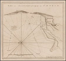
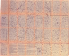
Detailed plan of "The Great Mountain of Gingee" and the small fort atop it, published by Thomas Kitchin.
The explanatory note continues that 10 men were sufficient to defend the fort against assaults.
The key locates a total of 12 places on the map.
Gingee
Gingee dates to the Kon Dynasty as a fortified royal center. It would later come under the rule of the Hoysalas in the later part of the 13th and in the first half of the 14th century and thereafter fell into the hands of the first rulers of Vijayanagara empire. The Vijayanagar dominion gradually expanded over South India and divided the administration into three important provinces, which were under the control of Nayaks. Under the Nayaks the forts were strengthened and the town was greatly enlarged.
The last Nayak of Gingee was forced to surrender to the Bijapur army in December 1649. Gingee became of greater strategic importance under the Bijapur governors. Bijapur was in possession of the fortress of Gingee until 1677, when Chatrapati Shivaji, the son of Shahaji took the fort during his Carnatic expedition.
The Mughals captured the fort of Gingee from Rajaram the King of the Marathas in 1698, early in 1698. Zulfikar Khan, the son of Asad Khan, the Grand Vizir in the court of Aurangazeb, was in command of the siege operation of Gingee and of its governor until he left the Carnatic after about a year from its fall.
After that Aurangazeb, granted a mansab of 2,500 rank and jagir of 12 lakhs to Raja Swarup Singh, a Bundela Rajput chieftain, along with the killedari (Fort Commandership) of Gingee in 1700 AD. Raja Swarup Singh died of old age in 1714. Hearing about the death of his father, Desingh, the son of Raja Swarup Singh, traveled to Gingee and control. Aurangazeb had granted a firman to his father and Desingh took formal possession of his father’s jaghir on ground of his hereditary right. Desingh did not receive a warm welcome from the Mughal officers. The Nawab of Arcot, Sadatullah Khan, who attempted to dispossess Desingh, pleaded that the firman was not valid. When Payya Ramakrishna, who was his secretary, informed him of the legal necessity of getting the firman renewed by the new Emperor before assuming the jaghir, Desingh replied that he had got the firman of Aurangazeb and that he need not apply to anybody else.
In fact, after regaining the fort from Marathas, Aurangzeb had first appointed Nawab Daud Khan as the deputy subhadar of the Deccan. Nawab Daud Khan removed his headquarters from Gingee to the town of Arcot, as he believed that the place was not healthy. This diminished the importance of Gingee. While shifting his headquarters, Daud Khan appointed Sadatullah Khan as his Diwan and Faujdar in 1708. Sadatullah Khan later became the Nawab of the two Carnatics in 1713, under Nizam-Ul-Mulk. He was the regular and acknowledged Nawab of the Carnatic between the years 1710 and 1732 AD. After the death of Raja Swarup Singh he renewed the demand for the arrears of revenue with his son Raja Desingh. This led to a battle between the two, which unfortunately ended in the death of the young and valiant Rajput, Desingh on 3 October 1714.He struggled at the young age of 22, against the powerful Nawab Sadatulla Khan of Arcot in a struggle that was hopeless from the outset (Desingh’s army consisted of only 350 horses and 500 troopers, while the Nawab’s army had 8,000 horsemen and 10,000 sepoys). The ballets are sung in and around Gingee till date about his bravery. However, the fortress of Gingee lost its pre-eminent position and political importance within a few years of the extinction of the Rajput rule.
Subsequently, the two European rival powers in India, the English and the French, got themselves involved in the internal quarrels and fights and the French won for themselves the Gingee fortress on the 11th Sept., 1750, under the initiative of Bussy. They took good care to secure the fort by a strong garrison, which was well supported with artillery and ammunition.
Gingee remained firmly in French possession until after the fall of Pondichéry to Sir Eyre Coote in January 1761. The English commander was Captain Stephen Smith. With the fall of Gingee the French lost their last possession in the Carnatic.
Gingee regained its political importance, for the last time in its fateful history, in 1780 AD, when Haidar Ali, helped by some able French Officers, invaded Carnatic with a force of 90,000 men. Haidar’s men appeared before the fortress and easily carried it by their assault in November 1780. The English re-conquered it at the close of the second Mysore war from Tippu Sultan in 1799.
Thomas Kitchin was a British cartographer and engraver. Born in Southwark, England, Kitchin was the eldest of several children. He was apprenticed to the map engraver Emanuel Bowen from 1732 to 1739, and he married Bowen’s daughter, Sarah, in December 1739. By 1741 Kitchin was working independently and in 1746 he began taking on apprentices at his firm. His son Thomas Bowen Kitchin was apprenticed to him starting in 1754. By 1755 Kitchin was established in Holborn Hill, where his firm produced all kinds of engraved materials, including portraits and caricatures. He married his second wife, Jane, in 1762. Beginning in 1773 Kitchin was referred to as Hydrographer to the King, a position his son also later held. He retired to St. Albans and continued making maps until the end of his life.
A prolific engraver known for his technical facility, clean lettering, and impressive etched decorations, Kitchin produced several important works throughout his career. He produced John Elphinstone’s map of Scotland in 1746, and the first pocket atlas of Scotland, Geographia Scotiae, in 1748/1749. He co-published The Small English Atlas in 1749 with another of Bowen’s apprentices, Thomas Jefferys. He produced The Large English Atlas serially with Emanuel Bowen from 1749 to 1760. The latter was the most important county atlas since the Elizabethan era, and the first real attempt to cover the whole country at a large scale. In 1755 Kitchin engraved the important John Mitchell map of North America, which was used at the peace treaties of Paris and Versailles. In 1770 he produced the twelve-sheet road map England and Wales and in 1769–70 he produced Bernhard Ratzer’s plans of New York. In 1783, he published The Traveller’s Guide through England and Wales.
![[Mumbai] Plan De Bombay et ses Environs](https://storage.googleapis.com/raremaps/img/small/75975.jpg)