|
||

|

|
|

|
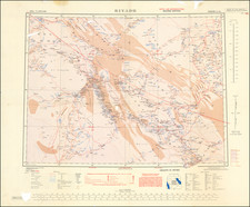
Detailed map of the Arabian Gulf, published by John Bartholomew & Son in Edinburgh.
The map extends west to the Riyadh area and southweast to Oman. The most unusual features of the map are the inset plans of the major cities of the region, including:
- Sharjah
- Dubai
- Ras Al Khaimah
- Al Manmah
- Doha
- Ad Dammam
- Kuwait City
- Muscat & Matah
- Abu Dhabi
- Riyadh
The map locates oil fields, oil pipelines, railways, airports, roads and tracks. Marshlands, wells, and salt deserts are also shown.
Interestingly, the map does not show international borders.
The map predates the start of production in the South Pars/North Dome Gas-Condensate field, which began in 1989. The North Field has almost as much recoverable natural gas as all other gas fields combined, and the exploitation of the field has dramatically changed the geopolitics of the Gulf.
It also predates the establishment of the major Emirati fields
![[ Ancient Persia ] Tabula Asiae V](https://storage.googleapis.com/raremaps/img/small/76351.jpg)
![Arabiae Veteris Typus [Map of Ancient Arabia]](https://storage.googleapis.com/raremaps/img/small/93085.jpg)