|
||

|

|
|

|
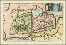
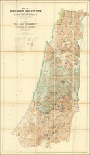
A Modern Survey Intended to Find the Route of Exodus, the Place Where Moses Crossed the Red Sea, and the Actual Location of the Biblical Mount Sinai.
Important document covering the region located at southwest of Jebel El Tih, the coast bordering the Gulf of Suez from Ras Abu Zenimeh to Ras Tor, and regions further to the interior.
The survey of the Sinai Peninsula was a spiritual offshoot of the Palestine Exploration Fund and was intended to answer questions regarding the actual physical locations of major events from the bible. On this map, the primary issues at hand were the route of Exodus and the actual location of Mount Sinai. This must be the reason for the focuses of the maps: routes of communication within the region, archaeological remains, and local Arabic toponyms. Many areas that would not have been relevant to questions of biblical historicity are left "unexplored". Areas of archaeological interest are labeled "stone circle" or "Inscriptions".
Some toponyms are underlined with red and blue pencil, with extensive old pencil annotations in the southeast quarter of the map, several of which identify routes through the region.
Many of the annotations are gathered around Mount Sinai.
The Ordnance Survey of the Peninsula of Sinai
In Joan Schwartz and James Ryan's book Picturing Place: Photography and the Geographical Imagination, the Ordnance Survey is summed up thusly (p. 234):
In 1868, a larger and more complex survey, again supported by private subscription, was organized to map the Sinai Peninsula. Although the size and complexity of the proposed survey were considered beyond the financial capabilities of the fledgling Palestine Exploration Fund, the survey, for which Wilson shared command with Captain H. S. Palmer was conceived in the spirit of scientific inquiry inspired by the success of the Jerusalem Survey and advocated by the Fund 'to apply the rules of science, which are so well understood by us in other branches, to an investigation into the facts concerning the Holy Land.'
The state goal of the survey was to resolve contemporary controversies in biblical and philological scholarship -- to determine the path of the Exodus, to identify Mount Sinai and to investigate the rock inscriptions in Wadi Mukatteb.
That there is a great need to carry out such a survey must be manifest to all students of Old Testament history; among the most important and interesting questions which are now subjects of inquiry [are the locations of] the Passage of the Red Sea, the route and encampments of the Israelites, and the identification of the Mountain of the Law-Giving.
Provenance and Annotations
The map is extensively annotated in English, with evidence of multiple hands, including annotations in pencil, black pen and blue and red pencil.
Provenance: Pastor Clement de Faye (Guernsey 1824 - Geneva, 1902). He was the translator of the book of Rawlinson on the Religions of the Old World (1887). De Fay's name, with the date of 1884, appear in ink on the verso. It is possible that Clément de Faye stayed in the region at that time and that he was the author of the annotations. The annotations also seem to relate to questions in biblical history and philology, as referenced by Schwartz and Ryan.