|
||

|

|
|

|
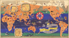
Extremely Rare Map of the World Showing Theory of the Winds
Very rare map of the world showing the system of wind currents developed by French naval officer Joseph Lartigue. One of only two known examples and the only one in private hands, this world map reflects the interest in the fledgling sciences of oceanography and anemology (the study of the winds) in the mid-nineteenth century.
In 1840, Lartigue submitted a chart along with an essay to the Académie des Sciences for formal review of his theories. The renowned explorer and oceanographer Louis Freycinet, as rapporteur of a committee of Academicians including himself, Keeper of the Dépôt de la Marine Charles-François Beautemps-Beaupré, and astronomer Félix Savary, found Lartigue’s work of high quality. They also asked that he extend his theories toward the polar seas.
This map is Lartigue’s answer to the committee, as the wind arrows are extended towards the south and north poles. This map covers the months of July, August, and September; although it is presumably one of an intended four, this is one of only two known examples of this map. There are only two known examples of January-February-March also known. It is unclear if April-May-June and October-November-December were not made or if they have not survived.
The base map reveals that a few areas of the globe were then still unknown to scholars. These include the eastern coast of Greenland, the Arctic, and especially the Antarctic. When this map was published, ca. 1855, the Arctic was being intensely explored, with expeditions setting out in search of the lost Franklin expedition.
The main purpose of the map was not geographic, but to inform viewers of the prevailing winds around the world during the summer months. Lartigue had sailed extensively and reviewed many logbooks and journals, recording the wind information from each. He then compiled these detailed maps, with arrows representing the direction of each separate breeze. Text boxes in the upper right and lower left explain his theories, which postulated that primary winds, those from the poles and the trade winds, determined a set of secondary winds—an integrated system of winds. A key in the lower right explains the type of wind indicated by each sort of arrow.
M. Joseph Lartigue
Joseph Lartigue was born in 1791 and died in 1876. In 1827, he published his first known work, Description de la côte du Pérou, entre 19⁰ et 16⁰ 20ʹ de latitude (Paris: Imprimerie Royal, 1827). He drew several charts of western South American coast, dating from the 1820s. Also in 1827, he published Instruction nautique sur les côtes de la Guiane française on behalf of the Ministre de la Marine et des Colonies (second edition in 1860). Both of these works identify him as a Lieutenant de Vaisseau, or a Lieutenant in the French Navy.
He was already known to the Académie when he submitted his wind theory and this chart, for he had published “Observations sur les divers changements de temps et de vents, occasionnés par les courants des marées” in the Memoire lu a l’Académie des Sciences in October 1836. His next publication is the Exposition du Systeme des Vents, in 1840, and on that title page he is identified as a Capitaine de Corvette, or Lieutenant Commander. He now also is Commander de la Légion d’Honneur, the third degree (of five) of the highest military honor in France—an award first created by Napoleon in 1804. The Exposition du Systeme des Vents was published in a second edition in 1855.
In 1842 he released a short bulletin, Notice sur les travaux et les ouvrages d'hydrographie et de météorologie de M. Lartigue, capitaine de corvette (Paris: impr. de Vve Bouchard-Huzard). A year later, he published Observations sur les brises de jour et de nuit: faites dans quelques parties des Pyrénnées, pendant les mois de juillet, août et septembre 1842 (Paris: Imprimerie Royal, 1843).
His interests in weather and winds seems to have endured for, in 1855, he published “Observations sur les orages dans les montagnes des Pyrénées et de leur analogie avec les ouragans des régions intertropicales” as part of the Comptes rendus des séances de l'Académie des sciences (December 1855). Not only did he keep in touch with the Académie, but he also read internationally, as evidenced by his Observations sur les données qui ont servi de base aux diverses théories des vents, et principalement sur le système de circulation atmosphérique de Maury (Paris: Robiquet, 1860), which discussed the wind theories of US naval officer and pioneering oceanographer Matthew Fontaine Maury.
Later, with the rank of Capitaine de Vaisseau, or Captain, he continued to produce works on his scientific theories about the winds and atmosphere. In 1858 he published Essai sur les Ouragans et les Tempêtes (Paris: Librairie Hydrographique de Robiquet). A decade later, he released Du mouvement de la mer et autres veritez naturelles dont les causes sont les plus inconnuës (Paris: E. Couterot et al, 1867) and Études sur les mouvements de l'air a la surface terrestre et dans les rêgions superieures de l’atmosphere (Paris: Arthus Bertrand, Èditeur, Librairie Maritime et Scientifique, 1868).
Lartigue’s final known publication was Note au sujet du rapport de MM. Crocé-Spinelli et Sivel, sur leur ascension du 22 mars 1874 (Paris: Impr. de Dupont, ca. 1874). This was on the subject, again, of the winds and the air. Joseph Crocé-Spinelli and Théodore Sivel were balloonists studying high altitudes and flight. They went on higher and higher flights in the early 1870s, when Lartigue wrote about them. They died on an attempt to break the altitude record on April 15, 1875 and were hailed as martyrs to science.
Although quite prolific, less is certain of Lartigue’s personal life. It is probably that he is related to Pierre Lartigue (1745-1826), the French hydrographic engineer.
The review and reception of the Systeme des Vents
Lartigue submitted his report for review by the Académie des Sciences after he annotated a Depôt de la Marine chart, dated 1835, and before 1840, when his pamphlet was published. As mentioned above, a committee was set up to perform the review, with three Academicians appointed. These were Freycinet, whose expertise in this area was well known, the head of the French charting body, Beautemps-Beaupré, and the astronomer Savary. Interestingly, both Savary and Freycinet died in summer 1841, only a year after this work was reviewed—this report was one of their last acts.
The committee took its time in reviewing the essay and the accompanying chart, as Lartigue had to request that they pass judgement on what they had examined so far, before he was recalled to duty at sea. The committee approved of his work. Their report, which was accepted by the Académie in spring 1840, according to the l’Institut periodical, was favourable and encouraged Lartigue to extend his work to the polar seas.
The committee’s report was included in a forward to Lartigue’s printed pamphlet and translates as follows:
MM. Beautemps-Beaupré, Savary and myself, have been charged by the Académie to examine a work by M. Lartigue, Lieutenant Commander, relating to an exposition of a new system of winds, to the 60th parallel. We have already been busy with this work for a long time; but, to continue it with all the care which its importance requires, we still have many facts to examine and to co-ordinate.
The author has appeared to us to have met and discussed all that, within the limits announced, the most skillful navigators have published in their observations and their journals. The discussion of such a mass of facts is immense, especially when we want to examine the new theory of which the principles themselves need to be verified and confronted with experience.
We were taking care of the rest of this work, when this officer told us that the exigency of his service obliged him to return to the sea soon, and that he would be satisfied to learn, from that moment, the opinion that the Academy had made its work.
Desiring to reconcile M. Lartigue's wishes with the laborious task which we have undertaken, we are happy to announce, in this way, that the work of this officer is of a high standard; that what we have already seen is the basis of all systems, and that this work has become, for us, the pledge of the sagacity and the instruction of the author. We propose, therefore, to the Academy to thank Mr. Lartigue for the communication he has made, and to urge him to complete his theory, as far as possible, in the polar seas; this book may later become the object of a larger and more complete report.
The conclusions of this report are adopted.
This chart is proof that Lartigue did try to continue his work. Lartigue’s work was also well-known in the mid-nineteenth century. For example, in a translation of A Complete Course on Meteorology by C. V. Walker with notes by Ch. Martins published in London in 1845, Martins had the following to say about Lartigue’s theory and chart (footnote, pp. 49-50):
M. Lartigue, captain of a brig, published in 1840 an important work, entitled Exposition du Systeme des Vents.
The author regards the two polar currents, and the trade-winds which result from them, as the base of the system of winds; he names them primary winds. He lays down the variation of the trade-winds according to their distance from the polar currents, the effects which result from their junction, and the formation of the variable winds of the torrid zone. Then he passes on to the history of secondary winds, and shews that the intensity of the variable winds of the torrid zone depends on that of the trade-winds. He then examines the manner in which the winds displace each other. The author attributes to the rotation of the earth very little influence over the direction of the trade-winds; the diurnal motion of the sun, and the configuration of countries, appear to him to have a much greater action. Finally, he gives some very curious details on the circular currents of air which are met with between Malaga and Gibraltar, and near the channels that separate the Antilles. A more-detailed analysis of this work would be unintelligible without having before us the large hydrographic chart which accompanies it. [emphasis added].
The essay on his wind system was also published in German as Das Windsystem, oder Die Luftbewegung an der Erdoberfläche und in den höheren Regionen der Atmosphäre (trans. Chrstian Gottlob Tröbst, Weimar: Voigt, 1856). However, the chart does not seem to have been translated into German as well, leaving the French as the only version extant.
Rarity
This map shows the winds for July, August, and September. Another map in the Bibliotheque Nationale in Paris shows January, February, and March. The Statbibliothek zu Berlin has both listed in their catalog, but we have located no other examples. The other two maps that supposedly would have finished out the year have not been found at the time of publication of this description.
This is an extremely rare map and is an important document that shows an emerging scientific discussion. Luminaries of ocean science like Freycinet lent their support to Lartigue’s fledgling research, which survives mainly through charts and publications which bear his name. The extreme rarity of this chart makes it an important item for further research and would make a fine addition to a collection of charts or of early oceanography.

![[Japanese World Map] Kaisei Chikyu Bankoku sankai yochi zenzu setsu (Revised map of all countries on the globe/ Map of the world and its mountains and oceans)](https://storage.googleapis.com/raremaps/img/small/43034.jpg)