|
||

|

|
|

|
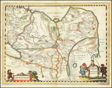
The Russian Empire Eyes Western China.
Important manuscript map of northern and western China and Mongolia prepared by K. Weber, Beijing, 1871, and copied by L. Brosse in St. Petersburg.
The map was the product of a major Russian expedition in China in the 1870s, the focus of which was to learn more about the region and explore the possibility of additional Russian intervention and territorial expansion in China. During this time, the Qing Dynasty was suffering from major internal strife, especially at the territorial periphery, namely due to the Dungan Revolt.
The Dungan Revolt saw the local Dungan people rebel against Han rule in western China, initially successfully. The revolt caused the Qing Dynasty to lose control of Xinjiang at a very opportune time for the Russian Empire, which was completing its conquest of neighboring territories in Central Asia. In 1871, Russia occupied Xinjiang, allegedly for the protection of its citizens and national interests. For a time, it seemed that Russia would formally annex Xinjiang and that China might attack Russia because of this encroachment, but in the end with the 1881 Treaty of Saint Petersburg, Russia left Xinjiang and China re-established control.
Russian explorations in Central Asia (1871)
It was at the initiative of the St. Petersburg Geographical Society and its President M. Semenov that Russian explorations of Central Asia began in 1871. From 1871, the explorer Prjevalsky lead the scientific exploration of almost all of Central Asia. The expedition started from Kiakhta, then crosses Mongolia from Ourga (Ulan Bator capital of Mongolia) to Kalgan (Zhangjiakou), on the traditional route of commercial caravans. Prjévalsky then went to Beijing. He first went to eastern Mongolia, crosses the In-chan and ends his journey in the capital of the Mongol principality of Ala-chan, known as Vei-tchin-fou.
In the lower right corner, the map says it was compiled by K. Weber in Beijing in 1871 and copied by L. Brosse in St. Petersburg in September 1871.
Weber made other Russian-language maps of China around this time. Including one of Hubei province, also published in 1871.

![[Macao, Hong Kong & Environs] Carte de L'Entree de la Riviere De Canton dans la Chine](https://storage.googleapis.com/raremaps/img/small/74473.jpg)
![[ China Sea / Luzon / Hong Kong / Canton / Formosa ] Bogt Toncqin (VOC - Dutch East India Chart by Its Chief Map Maker in Batavia)](https://storage.googleapis.com/raremaps/img/small/64690.jpg)