|
||

|

|
|

|
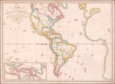
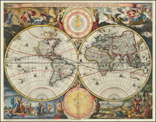
Rare separately issued English map of America, published in London by John Overton.
Following the death of Peter Stent from the plague in 1665, John Overton acquired his stock of maps and copperplates. However, unlike Stent's competitors, Thomas Jenner and Robert Walton, Stent had not prepared a set of maps of the continents. Overton first issued his set of continents in about 1668. The set was largely copied from the maps of Jenner and Walton, which in turn had been copied from earlier Dutch models.
As noted by Burden, Overton copied the decorative borders from Walton's 1658 map of America (which Walton had copied from Van der Keere and Visscher) and Jenner's 1668 map of America for the cartographic content. The large North Polar inset is copied from Walton, who in turn copies Van Den Keere and Visscher. The treatment of California is based upon Briggs.
The map curiously references New Jersey (Iarsey), although there is no sign of New York or Manhattan.
Portraits of explorers include:
- Francis Drake
- Ferdinand Magellan
- Christopher Columbus
- Amerigo Vespucci
- Olivier Van Noort
Overton's map, unlike its Dutch counterparts, has a crude folk-art like quality, reflective of a period when English engravers were far less skilled than their Dutch counterparts.
States and Rarity
There are two states of the map, both extremely rare.
- State 1: Dated 1668 in title
- State 2: Date removed and Overton's address changed to Iohn Overton at ye White Horse neere the Fountain Tavern Without Newgate.
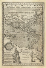
The popular misconception of California as an island can be found on European maps from the sixteenth through the eighteenth centuries. From its first portrayal on a printed map by Diego Gutiérrez, in 1562, California was shown as part of North America by mapmakers, including Gerardus Mercator and Abraham Ortelius. In the 1620s, however, it began to appear as an island in several sources. While most of these show the equivalent of the modern state of California separated from the continent, others, like a manuscript chart by Joao Teixeira Albernaz I (ca. 1632) now in the collection of the National Library of Brasil shows the entire western half of North Americas as an island.
The myth of California as an island was most likely the result of the travel account of Sebastian Vizcaino, who had been sent north up the shore of California in 1602. A Carmelite friar, Fray Antonio de la Ascensión, accompanied him. Ascension described the land as an island and around 1620 sketched maps to that effect. Normally, this information would have been reviewed and locked in the Spanish repository, the Casa de la Contratación. However, the manuscript maps were intercepted in the Atlantic by the Dutch, who took them to Amsterdam where they began to circulate. Ascensión also published descriptions of the insular geography in Juan Torquemada’s Monarquia Indiana (1613) (with the island details curtailed somewhat) and in his own Relación breve of ca. 1620.
The first known maps to show California as an island were on the title pages of Antonio de Herrera’s Descripción de las Indias Occidentales (1622) and Jacob le Maire's Spieghel Der Australische Navigatie (1622). Two early examples of larger maps are those by Abraham Goos (1624) and another by Henry Briggs, which was included in Samuel Purchas’ Hakluytus Posthumus or Purchas his Pilgrimes (1625). In addition to Briggs and Goos, prominent practitioners like Jan Jansson and Nicolas Sanson adopted the new island and the practice became commonplace. John Speed’s map (1626-7), based on Briggs’ work, is well known for being one of the first to depict an insular California.
The island of California became a fixture on mid- and late-seventeenth century maps. The island suggested possible links to the Northwest Passage, with rivers in the North American interior supposedly connecting to the sea between California and the mainland. Furthermore, Francis Drake had landed in northern California on his circumnavigation (1577-80) and an insular California suggested that Spanish power in the area could be questioned.
Not everyone was convinced, however. Father Eusebio Kino, after extensive travels in what is now California, Arizona, and northern Mexico concluded that the island was actually a peninsula and published a map refuting the claim (Paris, 1705). Another skeptic was Guillaume De L’Isle. In 1700, De L’Isle discussed “whether California is an Island or a part of the continent” with J. D. Cassini; the letter was published in 1715. After reviewing all the literature available to him in Paris, De L’Isle concluded that the evidence supporting an insular California was not trustworthy. He also cited more recent explorations by the Jesuits (including Kino) that disproved the island theory. Later, in his map of 1722 (Carte d’Amerique dressee pour l’usage du Roy), De L’Isle would abandon the island theory entirely.
Despite Kino’s and De L’Isle’s work, California as an island remained common on maps until the mid-eighteenth century. De L’Isle’s son-in-law, Philippe Buache, for example, remained an adherent of the island depiction for some time. Another believer was Herman Moll, who reported that California was unequivocally an island, for he had had sailors in his offices that claimed to have circumnavigated it. In the face of such skepticism, the King of Spain, Ferdinand VII, had to issue a decree in 1747 proclaiming California to be a peninsula connected to North America; the geographic chimera, no matter how appealing, was not to be suffered any longer, although a few final maps were printed with the lingering island.
The Overton family was a prominent part of the printing, and mapmaking, industry in London in the seventeenth and eighteenth centuries. John Overton (1639/40-1713) was the son of a tailor who apprenticed to Stationer Thomas Gould. He was made free of the Stationers’ Company in 1663. Two years later, London was struck by the Great Plague of 1665-6. Peter Stent, a leading printseller, succumbed and Overton took over his shop. This burned in the Great Fire of 1666, but Overton had rebuilt by 1669, when he advertised his wares from the White Horse on Snow Hill. Overton specialized in prints, portraits, and especially maps and topographical views.
John was likely married three times and had seven children. His eldest, Thomas, emigrated to America. His second oldest, Henry, was executor of John’s will when the latter died in 1713. Henry (1675/6-1751) acquired his father’s stock in 1707 and ran the shop until his own death in 1751. He published many maps, most focusing on the British Isles. His shop and stock passed to his nephew, another Henry, son of John’s fourth son, James.
Henry the Elder’s brother, Philip (ca. 1681-1745), was also a printer and mapmaker. Philip served as his father’s apprentice and was made free of the Stationers’ in 1702. His father set him up in the trade in 1707 and by 1710 he was working from the sign of the Golden Buck in Fleet Street. Philip specialized in fine arts prints, including Hogarth’s Hudibras set (1726), but he also sold many maps. At his death in 1745 he left his shop to his widow, Mary. She ran the shop and then married James Sayer, whose brother, Robert, became Mary’s assistant. He took over the business in 1748 and became a famous purveyor of maps, charts, and views.
Back at the sign of the White Horse, Henry the Younger continued the family business, expanding their stock to include a large collection of landscape views. He often partnered with Robert Sayer. He continued in business until at least 1764, when he drops out of the historical record.