|
||

|

|
|

|
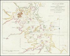
A rare 19th-century manuscript survey recording the division of common lands in the Lower Plains at the western end of Nantucket, a process as controversial as it was important.
The “Common and Undivided Lands” of Nantucket
In the 17th and 18th centuries the “Common and Undivided Lands of the Proprietors of Nantucket” were inviolable, set aside for grazing sheep, cattle, and horses; for gathering wood and peat; and for communal agriculture. Owning a “Sheep Commons” at that time meant having the right to pasture one sheep on the common lands. (8 Sheep Commons = 1 Cow Commons; 2 Cow Commons = 1 Horse Commons). This state of affairs continued well into the 19th century, well after most other Massachusetts towns had subdivided their common lands and distributed them among the citizenry.
“The Proprietors of common land in Massachusetts By and Plymouth Colony had only one object, which was to divide the land among the owners as speedily as it could conveniently be surveyed and investigated…. At Nantucket a widely different purpose animated the settlers. The thousand hills and vales were to remain common and undivided as one vast pasture over which sheep could roam in search of food and water. Ultimate division was never contemplated.” (Henry Barnard Worth, Nantucket Lands and Landowners, p. 199)
An exception was made for house lots in the town of Nantucket, beginning with the Wesco Acre Lots (1678), the Fish Lots (1717) and the West Monomoy Shares (1726). Each division was laid out into twenty-seven equal shares: one each for the twenty original proprietors, plus one-half each for the original fourteen half-share tradesmen. Those shares were apportioned among heirs many generations after the original Proprietors and Half-Share men had ceased to exist. Owners of portions of shares were free to sell to whomever they wished. The intricacies of land transactions within the town were carefully described and recorded, but the boundaries of the outlying lands, the former commons, were much more difficult to accurately document.
By the early 19th century, there was a movement among some of the Proprietors to divide and distribute the common lands so that each Proprietor could claim private property, fence it, and use it as he liked. Quaker historian Obed Macy saw this movement as the end of a way of life, of a “brotherly” sharing of property for the benefit of all. In 1811, Obed and his brother, Sylvanus, were the probable authors of a pamphlet published in Boston, titled “A Nest of Love Disturbed, or, The Farmer’s Dialogue,” wherein they lay out arguments for keeping the commons intact. They did not succeed in convincing the majority. The resulting “sheep wars” were eventually won by the wealthier proponents of private ownership, and the new rule was that any Proprietor owning a hundred or more Sheep Commons was eligible to have land set off to him. In 1820, the Proprietors voted to survey select areas of the commons, dividing each into twenty-seven equal shares.
Survey of the Lower Plains
Offered here is a mid-19th-century manuscript copy of one such survey, of common land in the Lower Plains (or “Planes”) area on the west end of the island just east of Long Pond. The survey was executed by islanders Solomon Coffin and Daniel Allen, and the original is in the Nantucket Registry of Deeds.
The survey covered an irregular area very roughly 350 by 320 rods in extent, the equivalent of a square mile or so. One side of the parcel butts up against the east shore of Long Pond, from the Gut south to Jeremy Cove, then extends to the east for the better part of a mile. As usual with these surveys, the parcel has been divided into 27 lots of equal extent (in this case, 18 ¾ acres). Several roads are laid out, uniformly three rods wide, so that each lot has ample road frontage. Some of the lots appear to have been subdivided, while lot 22 is “amended” by a small lot at the top of the survey, presumably to compensate for some inferior land.
At upper right is a long note describing the outer bounds of the parcel and of two other nearby parcels ordered surveyed at the same time. At lower right is a table listing the proprietors and the lots received by each. Among these are many descending from some of the earliest settlers of the island.
Some notes on the surveyors
Daniel Allen Jr. (1756-1843). Few documents remain to provide clues to the occupation and achievements of Daniel Allen Jr., aside from bills relating to driving sheep, marking sheep, and surveying. Records show that he made surveys with Walter Folger Jr. and his brother Aaron Folger, and that he was married to their cousin, Phebe Folger, with whom he had seven children. He and Daniel P. Macy surveyed a number of the 1821 divisions of common lands, and he worked with others to lay out town roads, and divide Tuckernuck Island. He appears to have been a trusted surveyor and draftsman.
William C. Folger (1806-91) was a descendant of Peter Folger, a half-share tradesman who was a poet, miller, translator for the local Wampanoags, and surveyor. The Folgers were a family boasting some remarkably brilliant and creative members, including Benjamin Franklin, grandson of Peter Folger. William C. Folger was the son of Rebecca Folger and her cousin Alexander Folger, receiving a double-dose of the Folger genes. An obituary in the Inquirer & Mirror sums up his accomplishments:
“Though possessing only ordinary educational advantages in his youth Mr. Folger early developed an aptitude for study and research and through life has ranked among the most intelligent of our citizens. When quite a young man he engaged for a while in the manufacture of oil and candles, then the leading industry of this place, his manufactory being located on Winter Street. Subsequently he taught school and for many years engaged in land surveying. For a long period and at the time of his death he held the commission of Justice of the Peace. Though of Quaker antecedents he long since identified himself with the Baptist denomination and for many years has been one of the senior deacons of the Summer Street Church. In abolition times he was conspicuously identified with the anti-slavery movement and in late years was actively interested in temperance work and other social reforms. But it is perhaps through his antiquarian research and genealogical lore that Mr. Folger has become most widely known. On local history and genealogy he has long been an accepted authority and during his many years of study and research has collected a vast amount of valuable data and statistics. He has contributed many valuable articles to the press in years past, and was consulted on matters of family history by Nantucket descendants the world over. He leaves a widow.”
Provenance
This survey originally belonged to a large archive of maps, plats, and documents in the possession of Frank H. and Clara Low (1925-2016). Clara was the daughter of Henry Coffin Everett (1891-1963) and the great-great-granddaughter of Henry Coffin (1807-1900), one of the key figures of 19th century Nantucket. Henry built the house at 75 Main Street, across from his brother Charles G. at 78 Main. The men were in the whale-oil business together in the firm C.G. &H. Coffin. When that industry failed in the mid-19th century, they—along with Henry’s son Charles F.—were early developers of a plan for Surfside to become a summer cottage community that would rival Siasconset, a thriving resort on the east end of the island. Charles F. Coffin also created a development south of the village of ‘Sconset called Low Beach.
Some of the surveys in this collection were drawn specifically for Henry Coffin Everett. Others not specifically surveyed for him, relate to areas of the island where he owned property that had descended to him from Henry Coffin— this included almost every part of the island from Madaket to Siasconset: Trotts Hills, the Plains, Smooth Hummocks, Surfside, Shimmo, Pocomo, Plainfield, and the Southeast Quarter. The various early surveys more than likely belonged to Henry Everett’s father, also named Henry Everett (1859-1945), and some date back to the original Henry Coffin. The collection represented a family’s real estate holdings in an era before the rampant development of outlying areas of the island that began in the 1980s. Clara Low was owner of much of the family property in the mid-twentieth century. She and her husband were involved in dozens of land transactions worth many millions of dollars.
![[ Temperance Allegorical View ] Black Valley Railroad. Tickets Sold at all Liquor Shops. Accidents by Collisions are Entirely Avoided, as no up Trains are Run Over the Road.](https://storage.googleapis.com/raremaps/img/small/101469.jpg)
![Carte Reduite Des Costes Orientales De L'Amerique Septentrionale . . . contenant L'Isle Royale . . . La Nouvelle Angleterre et la Nouvelle Yorc . . . MDCCLVII [with Plan of Boston Harbor] Plan du Havre de Baston](https://storage.googleapis.com/raremaps/img/small/80006.jpg)