


|
||

|

|
|

|
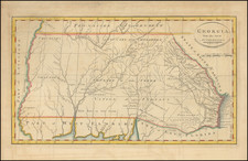
The Earliest Obtainable Map of the State of Georgia
First state of the earliest obtainable map of the state of Georgia, extending to the Mississippi, along with East and West Florida.
In the east, Georgia includes some coastal counties, towns, rivers, islands, lakes, etc. Tallassee County is identified as claimed by the State of Georgia previous to the Treaty of New York. The Akenfonogo Swamp is shown.
The Line settled by I Stewart, Supt. British Gov't is also shown, claiming for Florida regions which are here shown in Georgia. A number of Indian settlements are shown on the Lower Chatahochee River, and then again in the northern Cherokee lands. The Countries of the Cherokees and Creek are shown, along with the Seminole, Appalachy, Musckoggee, Chactaw and Chicasaws lands. The rivers which converge to form Mobile Bay show a number of early settlements, especially along the Alabama River. Most of the region covered is Indian land, with named settlements and other details. An interesting early map of Georgia, still including all of Mississippi and Alabama.
This map appeared in the 1795 edition of Carey's American Atlas.

![[ Extensively Annotated By An Early Owner ] Georgia from the latest Authorities](https://storage.googleapis.com/raremaps/img/small/100877.jpg)
![A Topographical Description of Such Parts of North America as are Contained in the (Annexed) Map of Middle British Colonies, &c. in North America [with map:] A Map of the Middle British Colonies in North America. First published by Mr. Lewis Evans ... in 1755; and since Corrected and Improved, as also extended with the addition of New England, and bordering parts of Canada; from actual surveys ... by T. Pownall](https://storage.googleapis.com/raremaps/img/small/100077.jpg)