|
||

|

|
|

|
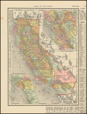
Irrigation and Oil Wells
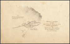
Rare map and promotional tract tor the Rosedale Colony, in Kern County, with a larger map of Kern County on the verso.
The map identifies the lands subdivided by the Kern County Land Company and the location of Rosedale Colony on the Kern River, with a marvelous contemporary promotional tract describing the commercial advantages of the region. The promotional tract identifies names or recent purchases and a host of other details.
The Kern County Land Company founded the Rosedale Colony in 1890. After building the Calloway Canal through the area, the company recruited settlers from the eastern United States and Europe.
The map of Kern County includes several oil fields, including:
- Sunset Oil Wells
- Buena Vista Oil Wells
The map was previously part of the archive of the Columbia Oil Production Company. We suspect the annotations in the area of the Smyrna Colony and Mira Monte Colony and other notes further south and west are quite likely the result of the company's oil exploration in the region.
Rarity
The map and promotional tract are of the utmost rarity. OCLC locates 2 copies (Bancroft Library and California Historical Society).
![[ Ventura ] Automobile Road Map of Ventura County California . . .](https://storage.googleapis.com/raremaps/img/small/99431.jpg)