|
||

|

|
|

|
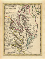
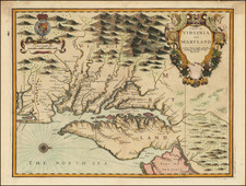
A Rare British Sea Chart of the Southeast and Mid-Atlantic Regions (The Colonial Williamsburg / William Wooldridge Copy)
Extremely rare separately issued chart of the coast from New York to North Carolina, which was issued separately and in Laurie & Whittle's rare North American Pilot, published in London in 1795 and later.
Centered on the the Chesapeake, the map extends north to Long Island and south to the area around Cape Hatteras and the Neuse River in North Carolina.
Includes a profile view of the Highland of Neversink and a second profile view of Cape Henry.
Despite the large scale of the map, there is considerable nautical detail of Hampton Roads and Chesapeake Ba
Laurie & Whittle reference Captain N. Holland as the maker of the map. In fact, there was no N. Holland, and this is likely a pseudonym for Samuel Holland. Holland and Gerard William DeBrahm were the two primary colonial surveyors for the British Colonies prior to the American Revolution. It is known that a number of the early colonial surveyors sold information to private publishers after the Revolution, using the information they gathered to make up for some of the lost compensation associated with their displacement.
While Holland may well have been the source, his assignment was the Northern British Colonies, making it more likely that the source of information for the map would have been DeBrahm, Bernard Romans, and the contemporary charts of Des Barres, Normal and Clark.
A finely engraved and highly detailed map.
Rarity
Earlier states of this map are in the collection of the New York Public Library, the Norman B. Leventhal Map Center at the Boston Public Library, and the Biblioteca Nacional de España. Provenance:
This copy of the map is published in William C. Wooldridge, Mapping Virginia, figure 200 and 200a, pp. 220-223.
James Whittle (1757-1818) was a British engraver and map printer. Whittle was employed by Robert Sayer (ca. 1725-1794). Together with Robert Laurie (1755?-1836), he took on Sayer’s business when the older man died in 1794. The two traded together as Laurie & Whittle until 1812, when Laurie retired. They had specialized in sea charts and maritime atlases. Whittle then partnered with Laurie’s son, Richard Holmes Laurie, until he died in 1818.
Robert Laurie (1755?-1836) was a British engraver and printseller who specialized in engraving portraits and in publishing maritime charts. His family originated in Dumfriesshire. As a young man he came to London and was apprenticed to Robert Sayer (ca. 1724-1794) in 1770. He received several awards in the 1770s for his mezzotint engraving and printing. He worked for Sayer as apprentice, assistant, and later partner.
In 1794, when Sayer died, Laurie took on his business alongside James Whittle, his fellow Sayer employee. Laurie managed the business and ceased almost all engraving. Instead, he oversaw the prodigious output of printed materials, especially sea charts and maritime atlases. He retired in 1812.
Laurie’s son, Richard Holmes Laurie, took over his part of the business and continued in business as Whittle & Laurie, rather than the previous Laurie & Whittle. Whittle died in 1818, leaving Richard as the sold proprietor of the business. Robert died in 1836 in Hertfordshire.