|
||

|

|
|

|
The Apotheosis of French and Indian War-Era Mapping of Hudson and Champlain Valleys -- With Revolutionary War-Battlefield Provenance.
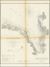
Large, finely-executed, Colonial-era manuscript map of the Hudson River-Lake Champlain Valley. The map was drawn in 1763-1765 by Francis Pfister, a notable surveyor, mapmaker and officer in the British Army, and taken from him after he was mortally wounded at the Battle of Bennington.
The map is the apotheosis of French and Indian War-era knowledge of the strategically vital corridor from New York City to Canada via the Hudson River and Lake Champlain. The map’s treatment of this route was compiled by Pfister exclusively from the two best sources available in 1763: his own maps of the Hudson Valley, developed during his time with the Royal American Regiment, and the William Brassier survey of Lake Champlain, executed under the orders of Jeffrey Amherst and completed in 1762. This is the last of Pfister’s general maps, and the only one to incorporate the Brassier survey. The map's place in the cartographic history of the late Colonial era has been confirmed through a comprehensive study of extant printed and manuscript maps of the region in British and American collections, which we will discuss in greater detail later in the description.
The map is not dated, but from internal cartographic evidence it may be dated 1763-1765, our reasoning is elaborated in the section on dating, below.
Pfister carried this map during the American Revolution and into the Battle of Bennington where he led a cavalry troop under overall command of Lieut. Colonel Frances Baum. There he was mortally wounded, captured by the Americans, and died soon thereafter. After his death, the map was taken as a prize by the American patriot Jonathan Armstrong. The map intriguingly bears evidence of its time on the battlefield in what appears to be a bloody handprint in the lower left corner of the southernmost sheet. For an 18th-century map, its provenance and lore are extraordinarily well-documented; the story of the map's battlefield capture and ownership by the Armstrong family are affirmed in printed accounts in the Vermont Historical Quarterly Gazetteer (1860) and Vermont Historical Magazine (No. XI, October 1867, p. 186).
Physical Description
The map is drawn in ink and watercolor on three separate sheets of laid paper (fleur-de-lis watermarks), with each sheet dissected in six sections and laid on 18th-century linen. The original case is covered in yellow silk and bears the title “MAP FROM NEW-YORK to St. JOHN’S.” The coverage extends from Sandy Hook, New Jersey in the South north to St. John’s on the Richelieu River with an east-west span of some 80 miles, centered on the Hudson River and Lake Champlain. The top sheet covers Lake Champlain, the middle sheet extends from lake George to the Catskills region, with detail of the Mohawk River, and the bottom sheet covers New York City, the lower Hudson Valley, and much of Long Island.
The map emphasizes the routes of communication along the Hudson-Champlain corridor. The roads on the east and west sides of the Hudson are charted, along with important settlements and forts. For a map of this scale, the hydrography of the Hudson River and Lake Champlain are exactingly rendered. Falls and ferries are mentioned on the Hudson and its tributaries.
On both the Lake Champlain and Mid-Hudson sheets the scale bars have been scratched out, as if they were found to be incorrect.
Cartographic Importance: Mapping the Great Warpath from 1757-1779
Beginning in the mid 1750s, British mapping of the Hudson-Champlain corridor developed in three stages: early French and Indian War maps by Charles Rivez and Samuel Holland (1756-1757); French and Indian War maps by Francis Pfister (1758-circa 1763); and Revolutionary War-period maps of Claude Joseph Sauthier and John Montresor (1775-1779).
To better understand the cartographic importance of the present map, we undertook a comprehensive study of public and private collections in the United States and the United Kingdom. This allowed us to place the map in the context of other known manuscript and printed maps of the Great Warpath from the relevant period (See Appendix.) We conclude from this review that Pfister’s manuscript, uniquely incorporating Brassier’s survey, is the finest general map of the Hudson River-Lake Champlain Valley corridor at the end of the French and Indian War. Further, as a general map it was not superseded until the Holland and Montresor maps of 1775.
Dating the Map
Determining the date of production of this map is not straightforward: It bears no written date, nor have we located any external evidence about its production. However, internal evidence helps establish a window of production of 1763-1765.
Two pieces of evidence support the terminus post quem: first, the map illustrates the "Canada line" border at the 45th parallel, which was established by the Royal Proclamation of 1763 following the Treaty of Paris. Further, the map’s treatment of Lake Champlain follows that of Brassier's survey, which, according to the correspondence of Jeffery Amherst and James Murray, was not completed until late 1762 or early 1763.
The terminus ante quem can be set at 1765 because the map does not make use of the John Collins-Charles Blaskowitz ‘65 survey of Lake Champlain, which fixed the Canada line border’s intersection with the northern part of lake (see Library of Congress G3802.C45 1765). This rendering of the border was reiterated by Sir Henry Moore and Guy Carlton's 1767 "actual observation" of the 45th parallel at Lake Champlain. Nor does the map reflect the 1771-1774 Valentine and Collins survey of the 45th parallel west of the Connecticut River.
Pfister’s misplacement of the Canadian border with respect to Lake Champlain is very unlikely to have happened after both the Collins-Blaskowitz survey and the Moore-Carlton observation. Pfister was an extremely accomplished mapmaker with connections to the highest levels of the British military in America. Because the position of the border was of vital interest to everyone in northern New York, the 1765 survey would have been available to Pfister shortly after the survey was completed. Even if Pfister had missed the 1765 survey, it is even more unlikely that he would have also been unaware of the 1767 observation.
Other than Pfister’s changes to Lake Champlain and the Canadian border, the map closely follows the cartography of his 1759 maps. No updates have been made to the mapping of the Hudson, and the landowner’s names present here are also present in some of his earlier maps.
Francis Pfister and the Life of this Map
Francis, sometimes Franz Josef, Pfister (ca. 1740-1777) was a German-born military engineer. He came to America sometime prior to September 1758 with the newly-formed Sixtieth Foot Regiment, also known as the Royal American Regiment, home to many of the British Army’s European cartographers. Pfister was only 16 or 17 at the time and had apparently trained in mathematics and engineering. He did not have a military rank and therefore likely came over as a gentleman-volunteer, which positioned him to socialize and dine with the commissioned officers. He served under the command of General Abercrombie.
Pfister was first commissioned as an eighteen-year-old ensign in the British Army in 1758. As part of his duties, he surveyed and drew a number of important manuscript maps, including at least six finely executed manuscript maps of the Province of New York (then including Vermont) in 1758 and 1759. Three of these are held at the British Library (King George Topographical Collection), one at the National Archives at Kew, and a fifth at the New York State Library (from the collection of Jeffery Amherst).
After his service in the French and Indian War, he settled in America, becoming a prominent landowner in the Hoosic Valley. When the Colonies rebelled, Pfister remained loyal to Great Britain. He was attached to Lieutenant Colonel Friedrich Baum, who, under orders from General Burgoyne, was tasked in August 1777 with the taking of an American supply depot at Bennington, Vermont. On August 15, 1777, Pfister, at the head of a troop of Loyalists, fortified the Tory Redoubt. The next day, amidst the fighting, he was mortally wounded.
Jonathan Armstrong, an American soldier, found and carried Pfister to his home roughly a mile and a half from the battlefield. Pfister died within 24 hours. Armstrong kept several of Pfister’s possessions, including this map with case, drawing instruments, his 1760 commission, and his contract for the Niagara Portage. As noted in the 1867 Vermont Quarterly Gazetteer (p. 160):
Among those of the enemy who lost their lives in [the Battle of Bennington] were the commander of the expedition, Col. Baum, and the leader of the tories, Col. Pfister. They were both mortally wounded and separately brought a mile and a half this side the battle ground to a house still standing opposite the papermill of Messrs. Hunter & Co. They both died within twenty-four hours and were buried near the bank of the river a few rods below the paper mill. There is nothing to mark the spot and the precise place of their internment is not known.
Of the relics of the battle remaining in the town, there is a broad sword which was taken from Col. Baum, on the field of Battle, by Lieut. Thomas Jewett, of Capt. Dewey's company. It was afterward purchased by David Robinson, and used by him as a Captain of cavalry, and subsequently as a field and general officer of the militia, and is still in the possession of his grandson, George W. Robinson.
One of the two persons who captured the wounded Col Pfister was Jonathan Armstrong, a volunteer from the vicinity of Bennington, and into whose hands there fell, as the spoils of war, a portion of his baggage, among which was found his commission, on parchment, as "Lieutenant in his Majesty's Sixtieth or Royal American Regiment of Foot," dated Sept. 18, 1760, and signed by Sir Jeffery Amherst; a set of draughting instruments, and a map of the rout from St. Johns through lakes Champlain and George, and along the Hudson to New York. The map is in three parts for the convenience of folding and use, the whole being about 4 feet long by 10 inches inside. The lakes and rivers are colored and the whole is so neatly and accurately done with a pen as to be scarcely distinguishable from a fine engraving. These relics are in the possession of L. B. Armstrong of Dorset, a grandson of the soldier into whose hands they fell on the battle field.
Two of the four brass field pieces are now in the Capitol at Montpelier, with the following inscription of ancient date, engraved on each, viz: "Taken from the Germans, at Bennington, Aug. 16, 1777."
From there, the items were passed down in the Armstrong family as heirlooms until the late-20th century. Armstrong’s descendants then sold the map to an antique dealer, by whom it was sold to the collector Walter O’Connor through his agent, named Grimison. We acquired the map at an auction of material from Walter O’Connor’s estate. At some point, other items taken from Pfister went into the Bennington Museum.
It is exceptional to have the complete provenance of such a map stretching back to its use and capture in an American Revolution battle.
We can trace only one other map by Pfister having passed through the market. A general map of the Province of New York was sold in the 1967 Sotheby’s sale of Jeffery Amherst’s manuscript maps. That map was in turn sold to the New York State Library by H.P. Kraus.
This is the best French and Indian War-era map of the most important French and Indian War campaign route, executed and kept by the man who made the official maps of the campaign for Jeffery Amherst. It is a relic of an American Revolution battlefield with unbroken provenance from the present back to the American patriot who seized it. All things considered, this is one of the finest 18th-century American maps have come to the market in the past decade.
Appendix: Cartographic Context
In a search for other general maps of the Champlain-Hudson corridor, we consulted the map holdings of the Library of Congress, New York Historical Society, New York Public Library, Fort Ticonderoga, New York State Library and Archives, Clements Library, Huntington Library, Vermont Historical, Massachusetts Historical, Boston Public Library Leventhal Collection, British Library, National Maritime Museum, and the National Archives at Kew. The study uncovered the following relevant maps:
1757 ca. Charles Rivez. A Map of the Province of New York and part of New Jersey. Manuscript. Kashnor Collection, Huntington Library (HM 15453).
1758. Francis Pfister. A map of the Province of New York, part of New England, with a part of New France. Manuscript. New York State Library and Archives 44847484. (ex heirs of Lord Amherst, through H.P. Kraus)
1759 ca. Francis Pfister. A Map of the Province of New York & Part of New England & New Jersey with a Part of New France. Manuscript. British Library King’s Topographical Collection. BL Add MS 57713.1.
1759 ca. Francis Pfister. A Map of the Province of New York & Part of New England & New Jersey with a Part of New France. Manuscript. British Library, King’s Topographical Collection. BL K.Top.121.1.
1759 ca. Francis Pfister. A Map of the Province of New York & Part of New England & New Jersey with a Part of New France. Manuscript. British Library, King’s Topographical Collection, BL K.Top.121.2.
1759. Francis Pfister. A Map of the Province of New York part of New England with a Part of New France. Manuscript. National Archives at Kew, CO 700/New York 24.
1768. Samuel Holland. The provinces of New York, and New Jersey... Printed.
1775. Samuel Holland. The province of New York, and New Jersey... Printed.
1775. John Montresor. A map of the Province of New York, with part of Pensilvania, and New England... Printed.
1776. Claude Joseph Sauthier. A map of the Province of New-York... Printed.
1777. Claude Joseph Sauthier. A topographical map of Hudsons River... Printed.
1779. Claude Joseph Sauthier. A chorographical map of the Province of New-York in North America. Printed.
![[Last of the Mohicans / New York] Carte dressee pour la lecture du Dernier des Mohicans Roman de J. Fenimore Cooper](https://storage.googleapis.com/raremaps/img/small/86045.jpg)