|
||

|

|
|

|
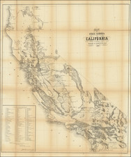
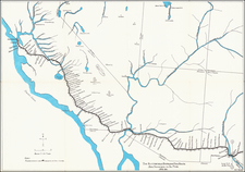
The First Official Map of Los Angeles County and The First Commercial Oil Field in the Western United States!
Rare wall map of Los Angeles County, published for the County Board of Supervisors and printed by Julius Bien in New York in 1877.
The Wildy & Strahlberg map of LA County is among the earliest surviving maps of Los Angeles and certainly one of the most important. The map was formally approved by the county board of Supervisors as the Official Map of Los Angeles County on Monday, May 3, 1878, (LA Herald, June 4, 1878).
Published at ime when the population of the City of Los Angeles was still less than 10,000 and the county perhaps twice that amount, the map illustrates the dawn of LA County's modern existence. The decision to publish map in 1877 was almost certainly associated with the completion of the Newhall Railway Tunnel in July 1876 and the arrival of the first train from San Francisco on August 12, 1876, launching Los Angeles toward a path to growth which began in earnest the following decade (Los Angeles had still only grown to about 11,000 people by 1880).
Oil In The West
The map identifies the "Oil Region of San Fernando," just north of the newly platted City of San Fernando. This would be a reference to the Pico Canyon Oil Field, generally consiered to be the first commercially successful oil well in the Western United States and the birthplace of the California Oil Industry.
Following the oil strike at Drake Oil Well in Pennsylvania in 1859, there was a short-lived oil drilling boom in California, but this was wiped out in 1867 when eastern oil could be sold cheaper. At the end of the first boom, 75 companies had drilled 60 wells in California, spending $1 million to produce $60,000 worth of oil.
According to the LA Times in 1882, the Pico Oil Spring was discovered in January, 1865, by Ramon Peria, a Mexican hunter. One day while hunting for deer he wounded a buck. He followed the trail and found it dead near the spring. The quality of the oil in the spring attracted his attention, being of a dark, green color and very thin, and so different from anything that he had ever seen, that he concluded it must be valuable. So he notified a friend of his, Jesus Hernandez, and they located the oil claim.
In 1875, the Star Oil Works hired Charles Alexander Mentry to supervise drilling in Pico Canyon. Mentry drilled 3 wells between 1875 and 1876 which showed promise, but it was not until the drilling of the Well No. 4 in July 1876, and subsequent strike on September 26, 1876 at a depth of 370 feet that the strike was confirmed. Well No. 4 would produced 25 barrels a day from the outset, with production continuing until 1990 when it was capped, making it also the longest continuously producing oil well in the world (although production had fallen to about 1 barrel per week by the 1960s).
Other Features of the Map
A number of larger land owners are identified in the rural and mountainous regions, as are numerous mineral claims. In Orange County, James Irvine is shown as the owner of 47,226 acres in Lomas de Santiago.
The early roads shown numerous ranch houses and stagecoach stations. The Hydraulic Mining Region on the Upper San Gabriel River is shown. Several early orange grove and farm associations are shown in the northern parts of the map, including the lands of the San Fernando Farm Homestead Association.
The map is catalogue of the California State Library simply as [Official] map, by J.H. Wildy and A.J. Stahlberg . . . 1877, the first map of Los Angeles listed in this reference work. The first notice of the map we could locate was in the Los Angeles Herald, February 10, 1878, which noted
We have examined the new map of the county prepared by Messrs. Wildy and Stahlberg, and which received such high commendation from the Board of Supervisors. It is a detailed and valuable map by tonwships and all noted points in Los Angeles county are laid down on it accurate and minutely. It will doubtlessly be largely in demand.
J.H. Wildy announced his intention to run for County Surveyor in the LA Herald on July 31, 1875, using General J.M. Baldwin and John Goldworthy as his references. By December 21, 1879, Wildy had relocated to Tulare, California, but had returned to Los Angeles shortly thereafter and was working as a Civil Engineer and Surveyor with an office in the Lichtenberger Block during 1884.
"A.J. Stahlberg drew the first map of downtown Los Angeles in 1876, the year the Southern Pacific Railroad fully connected the city to San Francisco". A copy of the map is illustrated in Taming the Elephant: Politics, Government, and Law in Pioneer California, by John F. Burns, Marlene Smith-Baranzini (p. 209), with a copy held in th Seaver Center for Western History Research, LA County Natural History Museum).
Rarity
OCLC lists copies at the Library of Congress and UCLA (possibly also UC Santa Barbara).
The Library of Congress example is heavily damaged: https://www.loc.gov/item/2012590103/