


|
||

|

|
|

|
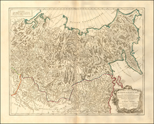
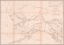
Rare English Edition of The First Map to Illustrate Russia's Great Northern Expedition
Nice example of Gerard Muller's seminal map of the North Pacific and contiguous coasts of America and Asia, published in St. Petersburg, the first official map to reflect the results of Russia's Great Northern Expedition.
Of great import, the map was the first to challenge (and in fact correct) the geographical misconceptions which appeared in Joseph Nicolas De L'Isle's map of the same region, issued in 1753, one year before the release of Muller's official account. The two maps defined the cartographic extremes which would be debated by the English, French and other mapmakers until James Cook's explorations of the Northwest Coast of America several decades later. This debate would include such topics as the existence of the Bay of the West, River of the West and several other remarkable Northwest Passage conceptions to which some mapmakers would cling until the final quarter of the 18th Century.
Great Northern Expedition
The Great Northern Expedition was one of the largest and best organized voyages of exploration, the results of which completely remapped most of the Arctic coast of Siberia and some parts of the Northwest coast of America, filling in vast amounts of previously unknown coastal details, which had been previously the subject matter of myth and speculation. Originally conceived by Russian Emperor Peter I the Great, the exploration was undertaken under the auspices of Russian Empresses Anna and Elizabeth, under the direction of Vitus Bering. The expedition lasted roughly from 1733-1743. The goal was to find and map the eastern reaches of Siberia, and explore and map the Northwest Coast of America.
The important achievements of the expedition included the European discovery of Alaska, the Aleutian Islands, the Commander Islands, Bering Island, as well as a detailed mapping of the northern and north-eastern coast of Russia and the Kuril Islands. The expedition also ended the myth of a massive land mass in the North Pacific.
Gerard Muller's Map
First published in 1754, Muller's map was the official Russian response to Joseph Nicolas De L'isle's surreptitious publication of his map of the same region, following his departure from Russia and return to Paris. The Russians believed that De L'isle had improperly used the information he had gathered while serving in St. Petersburg at the Royal Academy. Moreover, they were aware of his incorrect delineation of the Northwest Coast of America. Thus they encouraged Gerard Muller, a German cartographer working in St. Petersburg, to issue a map to correct De L'Isle's mistakes, as the official mapping from the Imperial Academy in St. Petersburg.
Muller's map was first issued in 1754, then reissued in 1758, 1773, and again in 1784. The 1758 edition adds a route across the Mer D'Ochozk, but is otherwise largely unchanged from the 1754 edition. The 1773 and 1784 editions were significantly updated, especially to show the discoveries of a number of Russian explorations, beginning in 1764, which produced new information on the Aleutian Islands and the western coast of Alaska.
The present map was issued by Thomas Jefferys in 1761, one of 4 maps to illustrate the first English edition of Muller's account, which was published by Jefferys in 1761 and 1764 under the title Voyage from Asia to America, for completing the Discoveries of the North West Coast of America. . . It is the first of several English maps based upon Muller and by far the earliest and most important.
Muller's map shows a dotted line suggesting the coast of America extending well to the west. The Russian explorations of the 1760s would later determine that the coastline was further to the east, leading to significant revisions of the map.. At the same time, the Russian explorer Ivan Synd, reported the existence of a number of fictitious islands in the middle of Bering's Strait, which were incorporated into the second edition of the map.
Muller's map is noteworthy in its omission of De L'isle's mythical "Sea of the West," although he does continue to hold out hope for a water route from the Pacific to the Atlantic via tentatively located "R. de l'Quest" connecting the northern California coast ultimately to Hudson's Bay. Streeter notes that Muller's map:
confirmed the existance of a body of water between Asia and America, the subject of much dispute during the previous two hundred years. It also showed the Kurile Islands correctly and suggested the outline of Alaska and the Aelutian chain. Though the Russian discoveries had been shown on the Delisle map . . .published in 1752, . . . this is the first map to give an approximate picture of what is now the Alaska peninsula. . . .
A foundational map for collectors of the Northwest Coast of America and Northeast Coast of Asia.
Rarity
The Jefferys map is rare on the market, although the complete book appears periodically on the market.
Thomas Jefferys (ca. 1719-1771) was a prolific map publisher, engraver, and cartographer based in London. His father was a cutler, but Jefferys was apprenticed to Emanuel Bowen, a prominent mapmaker and engraver. He was made free of the Merchant Taylors’ Company in 1744, although two earlier maps bearing his name have been identified.
Jefferys had several collaborators and partners throughout his career. His first atlas, The Small English Atlas, was published with Thomas Kitchin in 1748-9. Later, he worked with Robert Sayer on A General Topography of North America (1768); Sayer also published posthumous collections with Jefferys' contributions including The American Atlas, The North-American Pilot, and The West-India Atlas.
Jefferys was the Geographer to Frederick Prince of Wales and, from 1760, to King George III. Thanks especially to opportunities offered by the Seven Years' War, he is best known today for his maps of North America, and for his central place in the map trade—he not only sold maps commercially, but also imported the latest materials and had ties to several government bodies for whom he produced materials.
Upon his death in 1771, his workshop passed to his partner, William Faden, and his son, Thomas Jr. However, Jefferys had gone bankrupt in 1766 and some of his plates were bought by Robert Sayer (see above). Sayer, who had partnered in the past with Philip Overton (d. 1751), specialized in (re)publishing maps. In 1770, he partnered with John Bennett and many Jefferys maps were republished by the duo.