|
||

|

|
|

|
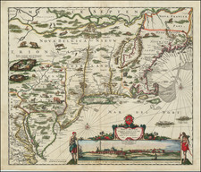
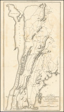
The Lands of the Bayard Land Company -- The Future Seneca Falls, New York.
Finely executed manuscript map of a portion of the Cayuga Reservation on the Seneca River, dated January 15, 1829, four years after the lands were sold by the Bayard Land Company.
The map illustrates the area 2 years prior to the incorporation of the Village of Seneca Falls and one year after the arrival of the Erie Canal to the region. The area shown is the area southeast of Van Cleef Lake, naming Bayard Street, Seneca Turnpike Road (now Seneca Street) and locating Washington Street (then unnamed).
The Explanation key reads as follows:
- 1st Road East of Grist Mill 1 1/2 Rods Wide
- 2. Road on Hill . . . 4 Rods Wide
- 3. Street from Turnpike to New Road 4 Rods Wide
- 4. Doted (sic) line between Canal and Mill Race a Road to be laid for Mutual accommodation of Mill Sites
- 5. Mill lots No. 1. 2. 3. 4. and 5, each 6 Rods Wide
- 6. Lots fronting Turnpike and Streets 4 Rods wide and 10 Rods long, except irregular Lots
- 7. Quarry Reservation, 12 Rods Wide
Other details shown on the map include the Milling House, Grist Mill, Oil Mill and Cooper's Shop.
Historical Overview - Bayard Company
Prior to 1825, the Bayard Land Co. owned the land on either side of the Seneca River in the future town of Seneca Falls. This gave it a monopoly on a potential water power from the mile-long rapids on this part of the Seneca River.
On Sept. 20, 1791, Elkanah Watson, Philip Van Cortlandt, Jeremiah Van Renssalaer and Stephen N. Bayard reached what is now Seneca Falls on their journey from Albany. They immediately saw the prospect of using the fast moving water for water-powered mills, and the prospect of attracting settlers. Watson also envisioned a canal around the falls.
The area was then known as Junius Lot No. 100 of the Military Tract. In 1792, Watson purchased 600 acres on the river’s north side from the State of New York. In 1794, Robert Troup, Nicholas Gouverneur, Stephen N. Bayard and Elkanah Watson formed the Bayard Land Company (BLC). Watson sold 100 acres of his land purchase to the Bayard Land Company. The purchase covered what became the First Ward of the village of Seneca Falls and the water power rights on the north side of the Seneca River. In 1795, Wilhelmus Mynderse bought a fifth interest in the Bayard Company and came to Seneca Falls at the age of 28 to act as the company’s on-site agent.
In 1795, BLC built the Upper Red Mills.. Also, in 1795, Mynderse built a double log house on the hill on the north side of the Seneca River. Mynderse lived in one end of the building and in the other kept a small store.
In the next few years, the Bayard Land Co. added property and build more mills. In 1798, the company purchased lot No. 6 of the Cayuga Reservation, on the south side of the river. This purchase consisted on 250 acres of land and included about one-half of the water power on the south side of the river. In 1807, the company built the Red Mills on the lower rapids on their Lot No. 6 property. In 1809, it added lot No. 9, which included the remaining water power on the south side of the river. Finally, in 1816, the company bought 450 acres of lot No. 86 from the heirs of Thomas Grant.
It was estimated that there was sufficient water power to operate 150 mill-stones, a remarkable amount of power in those years. Despite bigger plans, only a few acres of land were cleared and leased to tenant farmers. Two mills — the Upper Red Mills and the Red Mills — a cooper shop and a blacksmith shop were constructed. As a result, the settlement only consisted of about 300 inhabitants.
Despite offers, BLC refused to sell any portion of its lands. As early as 1817, BLC advertised the sale of its landholdings in Seneca Falls. Finally, in 1825, because of the personal financial difficulties of some of the partners, the company was compelled to divide and sell its property.
By 1828, the Cayuga-Seneca Canal had been linked to the Erie Canal, making transport of raw materials and finished goods easier and opening up the much larger market for items manufactured locally. On March 26, 1829, the Town of Seneca Falls was organized.
The Map
The following is excerpted from a description by Primitive Pieces in 2018:
The [present manuscript] map is delineated on a scale of 10 perches to an inch embracing approximately one square mile and most likely corresponds with Lot No.1 as shown on Dewitt’s 1795 manuscript “Map of the Cayuga Reservation Surveyed Into Lots”, being the northernmost limit of the Reservation as situated south of the Seneca River. Topography along the river and streams is denoted by hachure as are the river, canal and several mill races. “Lot No. 6” is subdivided into 70 parcels being arranged in an ”L” shape where the improved road of Bayard Street, Seneca Turnpike Road and an unnamed lane connecting Bayard and Seneca Turnpike are shown. Improvements include a Grist Mill, Mill House, Cooper’s Shop and Oil Mill along with two plank bridges crossing the canal and river with a third downstream of the Grist Mill crossing the river independently. Three parcels east of Bayard Street bear the names Freeman & Bascom being Ansel Bascom and Asher Tyler. The whole of Lot No 6 is bounded on the east, south and west side by perpendicular double rule lines and on the north by the Seneca River.
On an interesting historic note, the Seneca Turnpike Road here dissolves at the bank of the Seneca River bank and would not bridge the river until after completion of the middle section of the Erie Canal (1825) which is oddly absent here. The Erie Canal effectively paralleled the Seneca Turnpike through Cayuga County and should meet the river at the same general location.
An Explanation under the title provides additional survey information, of which Note 7 is particularly interesting stating Quarry Reservation 12 Rods Wide which we surmise to refer to the Erie Canal diggings themselves or the extraction of limestone to support canal construction. This 12 rod wide reservation is clearly denoted on the map by ruled dimension lines and hachure.