This item has been sold, but you can enter your email address to be notified if another example becomes available.


|
||

|

|
|

|
Stock# 58096
Description
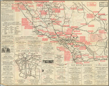
Highly detailed map of Los Angeles and Orange Counties, published by C.F. Weber.
The map shows early railroads, roads, wagon roads, mines, lakes, mills, and many other details.
A number of early ranchos are shown. There is additional detail of surrounding counties including Ventura, Kern, San Bernardino and Riverside.
One of the earliest obtainable separately issued maps of Orange County, which was formed in 1889.


![(Oil Wells - Santa Fe Springs, Los Angeles County, California) Sante Fee Springs [sic]](https://storage.googleapis.com/raremaps/img/small/95397.jpg)