|
||

|

|
|

|
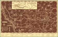
A Handsome Separately-Issued California Map
Rare separately issued map of Central California and the Virginia City-Comstock Mining Region, compiled by William Knight and published by the San Francisco firm of A. L. Bancroft & Co.
William Knight's map of Central California is one of the rarest separately issued regional maps of the period. Rumsey notes:
This 1871 map extends west to Virginia City in Nevada, north to Fort Bragg and south to Santa Cruz, adding Yosemite Valley and the Sierra Nevada gold country, Lake Tahoe, the Central Pacific Railroad completed over Donner Pass, and a large part of the Central Valley. At a scale of 12 miles to one inch, this map is twice the scale of the Bancroft/Knight Map of the Pacific States and the various spin off maps from it, thus showing more detail. Not listed by Vogdes or Wheat or in any references.
By the end of the 1860s, the significant growth in the mining regions of Central California and contiguous mining regions of Virginia City and the Comstock Lode created a demand for increasingly detailed regional maps. One of the earliest obtainable separately published maps of Central California to provide a usable depiction of the region was William Knight's Map of Central California. This highly readable map provided a detailed look at the roads, railroads, rivers, and towns in the region, extending to Storey County, Ormsby County, Douglas County and the mining regions around Virginia City, Carson City, Auburn and Reno.
Unlike earlier maps of California & Nevada, the present map was offered in a very usable format and was undoubtedly popular among the miners and other travelers arriving in San Francisco to seek their fortunes in the region. In describing the work of William H. Knight, Wheat proclaims:
Some extraordinarily fine maps of California had been issued on the Pacific shore during the previous decade, but nothing comparable in geographic reach to the map William H. Knight compiled for H.H. Bancroft…. Knight traveled overland to California in 1859, and next year entered the employ of H.H. Bancroft. By December, 1860…he had begun his labors on both the Hand-Book Almanac for the Pacific States and on 'a map to accompany the Hand-Book'…. Knight's map [of the Pacific States] belongs to the supreme category, the cartographical landmarks."
This map, which has its roots in Knight's map of the Pacific States, was apparently first conceived of in 1869, when the southwestern section of the present map (12 x 9.5 inches) was issued as a separate map, with the cover title: Bancroft's Map of Central California Bancroft no doubt quickly recognized that a map which extended only to Stockton and Sacramento Counties in the east was of little use, quadrupling the size of the map to 20 x 17 inches in 1871.