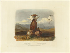
The item illustrated and described below is sold, but we
have another example in stock. To view the example which
is currently being offered for sale, click the
"View Details" button below.


|
||

|

|
|

|
Stock# 5804
Description
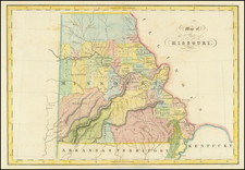
Scarce early map of Missouri, hand colored by counties. Many of the western counties are Indian Lands, such as Kickapoo, Delawares, Shawnees, et. The Boundy Lands are shown in the North. A massive Wayne County dominates the south. A number of early towns are shown, primarily along the Missouri and Mississippi Rivers, although no sign of Kansas City. Liberty, Ft. Osage, Buffton, Lexington, Jefferson, Charitson, Franklin and Boone are all shown on the western part of the Missouri, as is Ft. Osage. One of the earliest separate maps of the state published outside of America and a fascinating map of the state, shortly after statehood. Gorgeous full color example. Full color examples are rare on the market.

![[Report and] Map of an Exploring Expedition to The Rocky Mountains in the Years 1842 and to Oregon & North California in the Years 1843-44 By Brevet Capt. J. C. Fremont of the Corps of Topographical Engineers . . .](https://storage.googleapis.com/raremaps/img/small/88488.jpg)
![[French & Indian War] Carte Des Possessions Francoises et Angloises dans le Canada et Partie de la Louisiane . . . 1756](https://storage.googleapis.com/raremaps/img/small/94026.jpg)