|
||

|

|
|

|
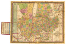
Detailed, early lithographed map of Milwaukee, published in Milwaukee by Lipman and Riddle.
The map features rail lines and the street grid in downtown, with almost all of the streets named. It also details subdivisions that are beginning to extend into the surrounding area.
There are earlier printed maps of Milwaukee, but all separate medium-to-large-format maps of the city from before the late 19th century should be considered rare.
Directory
8vo. viii, 288 pages; Appendix, which includes a list of local government officers, a post office directory for Wisconsin and a classified directory of businesses, schools, etc. and this followed by eighteen pages of local ads, most illustrated. An ad for Lipman & Riddle's Lithographic Establishment tipped into the back ads. Quite worn, the boards showing through along the tips and a split in the fabric along the spine, about 50% down. Rare; no OCLC entry found as of August, 2018.
The directory provides a good view of commerce and development in the city, at this fairly early stage.

![[Volk Field Air National Guard Base] Map Showing the Vicinity of Camp Douglas, Juneau Co., Wis.](https://storage.googleapis.com/raremaps/img/small/83882.jpg)