|
||

|

|
|

|
A Rare London Monuments Map
A scarce 1887 pictorial map of London by Charles Smith and Son.
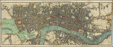
The map is centered on the Royal Courts of Justice, extending from Kensington Palace to the Tower of London and from Islington Green to Kennington Oval and Park.
London's developing transportation network is highlighted in red. Important monuments and even parks are highlighted with vignette illustrations of the buildings themselves.
The map is modeled after similar maps of Paris that were issued in the late 19th to the early 20th century for the 'Grand Tour' tourist market. While maps of Paris in this style were issued by a number of different publishers, the style is quite unusual for a London map.
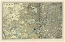
The present map was first issued by Charles Smith and in 1867 and went through at least 8 iterations. The earliest versions of this map were monochrome, as color printing had not yet become readily available for mass market productions. At least 7 subsequent editions followed, each offering minor updates to the content reflecting the construction boom London was then experiencing. The present example, 1887 or the 7th state, is one of the first editions to employ a full four-color printing process. It also extends the scope of the map east of the Tower of London to include most of Whitechapel.
![[A View of the West Side of London Bridge in the Year 1710, from an Engraving by Sutton Nicholls]](https://storage.googleapis.com/raremaps/img/small/86990.jpg)
![[ London ] A New and Correct Plan of the Cities and Suburbs of London & Westminster Borough of Southwark with the Country adjacent the New Buildings Roads](https://storage.googleapis.com/raremaps/img/small/102623.jpg)