


|
||

|

|
|

|
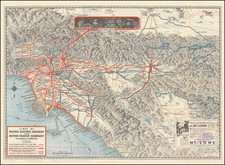
The First Large Format Map of Central Napa County
Fine Map of Central Napa Valley, centered on St. Helena, published by E. W. Woodward & Co. in St. Helena.
This is the earliest map to focus on the central part of the County and the regions being developed and cultivated for winemaking grapes.
The map includes a large town plan of St. Helena and a smaller plan of La Jota Rancho or Howell Mountain.
Finely detailed map of a portion of Napa Valley, extending from Yountville in the southeast to Bale Station in the northwest, following the line of the County Road from Napa to Calistoga diagonally across the map.
The map identifies a number of Wine Cellars, reflecting the main buildings of some of California's earliest winemakers, including:
- Rutherford
- Beringer
- Charles Krug
- Laurent
- Weinberger
- Beretta
- John Thoman
- York
- Lyman
- Fulton
- Scheffler
- Bourn
- Wheeler & Allen
- James H. McCord
- Gottlieb Groezinger
- Pellett
- Heymann
- Fountain
- Memond
- Chaix
- Magetti
- Jeaumond
Rarity
The map is very rare. OCLC locates 2 examples. Bancroft Library and UC Davis.
![(California - 19th-Century Photographs) [Album of 33 photographs of California, Oregon, and Washington, including Yosemite Valley, Stanford University, Sutro Heights in San Francisco; Mt. Hood; Mt. St. Helens; Portland, Oregon]](https://storage.googleapis.com/raremaps/img/small/94083.jpg)
![[Esparto, California] Map Showing Subdivisions of the Bonynge Tract and the Position of the Townsite of Esperanza Yolo County California... 1887-1888](https://storage.googleapis.com/raremaps/img/small/83457.jpg)
![[Escondido Area]](https://storage.googleapis.com/raremaps/img/small/71890.jpg)