
The item illustrated and described below is sold, but we
have another example in stock. To view the example which
is currently being offered for sale, click the
"View Details" button below.
![Map of the States of North & South Carolina [Large Charleston Inset] By Hinton, Simpkin & Marshall](https://storage.googleapis.com/raremaps/img/small/91846.jpg)
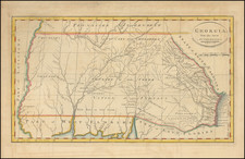
1832 Hinton, Simpkin & Marshall
$ 345.00


|
||

|

|
|

|
Stock# 5779
Description
Scarce early map of the Carolinas, hand colored by counties. Primitive county configurations still appear in the west. Shows towns, roads, rivers, mountains, lakes, post offices, court houses, rivers, Indian Villages, forts, etc. Excellent plan of Charleston, predating the earliest plan to appear in an American Atlas. Highly detailed map, showing towns, Indian Villages, forts, roads, rivers, mountains, lakes, etc. One of the earliest separate maps of these states published outside of America. Gorgeous full color example. Full color examples are rare on the market.

![[ Port Royal, South Carolina ]](https://storage.googleapis.com/raremaps/img/small/81298.jpg)

![(18th-Century Southern Borderlands) [Collection of manuscript letters to Secretary of War James McHenry from confidential U.S. agent John McKee, relating to southern borderlands, Native Americans and Panton, Leslie & Co.; a letter from John McKee written from Mobile, Alabama, to William Blount of Blount's Conspiracy fame; a letter from William Panton concerning John McKee; and letters from Felix D. St. Hilaire, concerning General Victor Collot]](https://storage.googleapis.com/raremaps/img/small/90005.jpg)