|
||

|

|
|

|
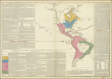
Scarce example of De Vaugondy's first large format map of North America.
The region east of the Appalachians is referred to as Chouanous et Cheraquis. Extensive notes on the Mississippi Valley Indians, French and English forts and other details. The river systems which drain into the Mississippi are also of note, along with the Belle Riviere, which seems to extend from southern Kansas or northern Oklahoma to the west, quite uniquely and mythically so. The coast of California still includes Nlle. Albion, Quivira and the entrance discovered by Martin d'Augilar. The lands to the north are Terres Inconnues. The Missouri River extends far into the west.
This first map is very different than the map included in later editions of De Vaugondy's atlases and was probably originally a separate issue.
The early example pre-dates the inclusion of the large inset map in the upper left corner of the map (showing the Northwest Part of America) and offers a very different treatment of the Great Lakes and the Midwest, among other changes.
Gilles Robert de Vaugondy (1688-1766) and Didier Robert de Vaugondy (1723-1786) were influential figures in the realm of 18th-century French cartography. Originating from Paris, their contributions to mapmaking were significant during an era of expansive geographical exploration.
Gilles Robert de Vaugondy entered the world of cartography not through family tradition but through personal interest and the budding opportunities of his time. Born in 1688, he worked during a time when Paris was becoming a central hub for cartographic activities. Gilles often incorporated the latest findings from explorers into his maps, making them sought-after for their contemporary relevance. His connections weren't limited to his immediate circle; he frequently interacted with other key mapmakers, staying updated on the latest techniques and findings.
His son, Didier, was born in 1723 and had the advantage of growing up surrounded by maps and globes. While his father was renowned for maps, Didier made a name for himself in the field of globemaking. His globes were some of the most precise and detailed in France, gaining recognition even among the royalty. In addition to his work in cartography and globemaking, Didier had a keen interest in education, especially after the expulsion of the Jesuits from France. He stepped in to produce geographical educational materials, fulfilling a newfound need.
The maps and globes produced by the Vaugondys remain an enduring testament to the peak of French cartography during the Enlightenment. Their works, characterized by precision and the inclusion of contemporary findings, helped to shape our understanding of the world during a transformative period in European history.
![[ Sea of the West ] L'Amerique Septentrionale divisee en ses principaux Etats . . . 1782](https://storage.googleapis.com/raremaps/img/small/80228.jpg)
![Charte von Nord-America Prag 1818 [Rare Alaska Inset Map]](https://storage.googleapis.com/raremaps/img/small/72184.jpg)