|
||

|

|
|

|
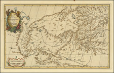
An Important Early Sea Chart of the Area around Hong Kong and the Pearl River Delta Updated To Incorporate Placenames in Chinese
Rare separately published chart of the areas between Canton (Guangzhou), Hong Kong to the islands around Hong Kong, with a large inset chart of the Pearl River Delta, published in London by James Horsburgh Hydrographer, for the East India Company in London.
First issued by Horsburgh in 1831, this 1847 edition incorporates the surveys of Edward Belcher's surveys in 1840 and includes extensive and substantial changes from the original chart. http://lunamap.must.edu.mo/luna/servlet/detail/MUST~2~2~363~466:Chart-of-Choo-Keang-or-Canton-river
The present edition provides for the first time a number of place names and elevations on Hong Kong Island and a block plan for Victoria. However, unlike the 1831 edition of the chart, the present example adds the major place names throughout the map in Chinese.
Rarity
The chart is very rare. OCLC locates 1 example of the 1831 edition (Harvard -- illustrated above) and an 2 examples of the 1847 edition (American Geographical Society Collection at UW Milwaukee and Boston Public Library).
The chart is not recorded in the Hong Kong Maritime Museum's Charting the Pearl River Delta.
James Horsburgh (1762 -1836) was a Scottish hydrographer who worked for the British East India Company (EIC) and charted much of China, Southeast Asia, India and contiguous regions in the late eighteenth and early nineteenth centuries.
Horsburgh went to sea at the age of sixteen and was captured and imprisoned by the French at Dunkirk. After his release, he made voyages to the West Indies and Calcutta. In 1786, as first mate in the Atlas, Horsburgh sailed from Batavia to Ceylon and was subsequently shipwrecked on the island of Diego Garcia. This disaster influenced him in his decision to produce accurate maps after he found his way back to India.
EIC hydrographer Alexander Dalrymple published three of Horsburgh’s earliest charts of the Straits of Macassar, of the western Philippines, and of the tract from Dampier's Strait to Batavia. In 1799, Dalrymple published Horsburgh’s Observations on the Eastern Seas on behalf of the EIC.
Meanwhile, Horsburgh continued his sailing career in the Carron, which had been taken up by the British government as a transport to the West Indies and, on his return to England, sailed again for Bombay. There, in April 1798, he was appointed to the command of his old ship, the Anna, and during the next seven years he made two voyages to England, besides several to China, Bengal, and Madras.
On the return trips to England in 1799 and 1801, Horsburgh became acquainted with the London scientific community including Sir Joseph Banks, the astronomer Nevil Maskelyne, and Henry Cavendish. Horsburgh kept barometric records for Cavendish during his voyages from 1802 to 1804, which elucidated the diurnal variation in the open sea between 26°N and 26°S. It was these measurements and his high society contacts that assured Horsburgh nomination and approval as a Fellow of the Royal Society upon his retirement from the sea in 1806.
Horsburgh continued to publish on nautical navigation. In 1806, he released Memoirs Comprising the Navigation to and from China. Next, in 1809 and 1811, Horsburgh finalized Directions for Sailing to and from the East Indies, China, New Holland, Cape of Good Hope, and the interjacent Ports, compiled chiefly from original Journals and Observations made during 21 years' experience in navigating those Seas, also known as the India Directory. These publications made Horsburgh a likely candidate for the position of hydrographer to the EIC, a post he gained in 1810. While serving as hydrographer he revised the Directory, with subsequent editions in 1816-7, 1826-7, and 1836. He also oversaw the compilation and publication of the EIC’s Atlas of India in 1827.
Horsburgh died in 1836. However, his legacy lived on. Friends and admirers in Canton raised a memorial subscription and erected the Horsburgh Lighthouse on Pedro Branca in the Strait of Singapore. With the permission of his children, the Admiralty took up the Directory and released editions in 1841, 1852, 1855, and 1864. After his death and with the demise of the EIC, his charts passed to the Admiralty Hydrographic Office, who reissued them.
![Expedition Citroen Centre-Asie 3eme Mission G.-M. Haardt - L. Audouin-Dubreuil [with 2 official pamphlets for the route, etc.]](https://storage.googleapis.com/raremaps/img/small/63033.jpg)
![[Guandong and Hainan, China] Province De Quang-Tong](https://storage.googleapis.com/raremaps/img/small/57106.jpg)