|
||

|

|
|

|
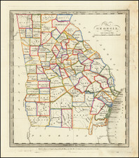
Detailed map of Georgia, based upon the 1822 map by Carey & Lea. The western counties are still unformed and classified as Indian lands, including the Cherokis and Lower Creek. Massive Appeling, Irwin and Early Counties dominate the south and are noted as being Indian Territories pursuant to the treaty of Ft. Jackson. The map shows counties, towns, roads, rivers, etc.
Interesting text in French shows numerous details concerning Georgia, including Rivers, Climate, Towns, Education, Religion, Commerce, Indian Details, Government, History, all the Governors beginning with Oglethorpe, and important Revolutionary War battles.
Jean Alexandre Buchon (1791-1849) was a French scholar and historian. Born as the French Revolution raged, Buchon was dedicated to recovering France’s history in order to help the country heal and grow. He gathered French stories and published them as part of Collection des chroniques nationales franciases ecrites en langue vulgaire, du XIe au XVIe siècle (4 vols, 1824-1829). He also compiled and published an exploration collection and several histories, particularly about medieval France.
For geography, his most important contribution was publication of the French edition of Carey & Lea’s American Atlas in 1825. Each page of the atlas includes highly detailed text about the state or territory depicted, as well as a map of the area. The French edition is generally considered in high regard as compared to other editions, as it has quality paper and superior engraving.
![[ Georgia Coast ] Sex alia flumina a Gallis observata. IIII.](https://storage.googleapis.com/raremaps/img/small/97965.jpg)
![[ Extensively Annotated By An Early Owner ] Georgia from the latest Authorities](https://storage.googleapis.com/raremaps/img/small/100877.jpg)