


|
||

|

|
|

|
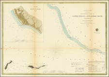
Charting the Oregon and Northern California Coastline in a Gold Rush
Fine US Coast Survey chart showing the western coastline from the mouth of the Umpqua River in Oregon to Cape Mendocino, California. First published in 1850, it details the coasts of Oregon and Northern California in the wake of the Gold Rush and at a time when the region was just beginning to be recorded in detail by Americans.
The chart is the result of an original survey conducted by Lieutenants William P. McArthur and Washington A. Bartlett on behalf of the US Coast Survey. It includes coastal settlements, as well as nautical information like sounding depths. Inland, two columns of sailing instructions offer information to the sailor, as do coastal profiles of Cape Mendocinio and Trinidad Head.
Indigenous presence is evident on the chart, which includes “Indian Villages” along the coast just south of Rogues’ River (Rogue River). The chart mentions Indian populations again in its sailing instructions: “From Cape St. George to Cape Oxford, the coast is thickly inhabited by bands of wild Indians, and care is necessary to not be surprised by them.” At the time of initial publication, the original inhabitants of the area still outnumbered white settlers, but they were quickly being overwhelmed by prospectors and homesteaders.
Other landmarks are also tied to the Gold Rush. For example, Humboldt City and Humboldt Harbor are named for Alexander von Humboldt, one of the most famous European explorers and naturalists of the nineteenth century. However, Humboldt City no longer exists—it was deserted in 1851 shortly after the creation of this chart. The chart similarly features Union Town, a former mining town that is no longer in existence. Just north of Union Town is Trinidad City, the oldest town on Northern California’s coast, which served as a valuable port for nearby mines. It was founded in 1850 but, like many towns in this region, declined in population by the close of the decade as the supply of gold dwindled. These towns can be used as markers for the abrupt rise and fall of the gold mining industry in California, and for the way it served as a hopeful prospect for new wealth in the minds of many Americans.
Early European and American encounters on the Pacific Northwest Coast
Europeans attempted to map the Pacific Northwest long before they actually visited the area. Most early depictions of the region use it as a staging ground for a passage, the Strait of Anian, or a river or inland sea that might connect Atlantic to Pacific. For example, the 1582 Illustri Viro Domino Phillippo Sidnaeo Michael Lok shows a passage in roughly 45°-48°N latitude. The Pacific Northwest was also the supposed location of various specious, yet tantalizing, straits such as those of Martin Aguilar, Juan de Fuca, and Admiral de la Fonte.
Although nominally controlled by the Spanish, the colonizers of Mexico seldom sailed farther north than the California coast. Instead, they focused on the Acapulco-Manila treasure galleon loop that was established in 1565 and continued until 1815. However, ships did sometimes go astray. The Beeswax Wreck, so called because the cargo contained tons of beeswax and candles, as well as Chinese porcelain and other goods, is a wreck that was located on the Nehalem Spit and was first reported by fur trader Alexander Henry in 1813. Radiocarbon dating and historical records indicate that this was most likely the Santa Cristo de Burgos, which left Manila in 1693 and then disappeared, becoming one of the Pacific Northwest’s earliest European shipwrecks.
Following the third voyage of James Cook (1776-1780), Europeans and Americans hurried to cash in on the lucrative fur trade in sea otter, beaver, and other animal pelts. The Spanish performed a series of reconnaissance voyages beginning in 1774. The Russians had been coming to Alaska periodically for pelts since the 1740s and they set up their first permanent settlement in 1784. Around the same time, fur traders began arriving by sea; James Hanna, of the Harmon, is often cited as the first, arriving in Nootka Sound in 1785. Within a year, several other commercial ships had also visited the site.
One of the most famous commercial ships to visit the coast was the Columbia Rediviva. One May 11, 1792, the Boston ship, under Captain Robert Gray, made it over the bar and into the mouth of a large river. He called the waterway after the ship, the Columbia. Another trading vessel, the Jenny, also made it over the bar later in 1792, as did one of the ships from the Vancouver expedition.
The Jenny also visited what is now Winchester Bay, located farther south on the Oregon Coast. He called it Sidman Bay, a derivation of the name of the Bristol-based vessel's owner, Sydenham Teast. The bay is the mouth of the Umpqua River, which is the northernmost feature on this chart.
Trade and settlement increased in the early-nineteenth century, especially in California. Farther north, the expeditions of Lewis and Clark reached the Pacific on their overland expedition in November 1805. Fur companies operated across the Pacific Northwest with bases on and near the mouth of the Columbia, but they also ranged considerably farther south.
On January 24, 1848, James Wilsom Marshall found gold flakes in the American River while building a sawmill for John Sutter. This sparked the Gold Rush. Tens of thousands flocked to California from around the world. The event also ushered California to an accelerated bid for statehood, which was granted on September 9, 1850, while this chart was being made.
The Surveying Expedition of McArthur and Bartlett
The chart includes a ship’s track, that of the US Coast Survey schooner Ewing. Spurred by the focus on the west coast inpsired by the Gold Rush, the Coast Survey ordered Lieutenants William P. McArthur and Washington A. Bartlett to survey the coast north of San Francisco for future development sites, potential locations for lighthouses, and accurate hydrographical information. They set off in the Ewing on April 3, 1850 and achieved their goals despite serious issues with manning; some of the crew wished to head to the gold fields rather than sail.
Much of the surviving documentation of this voyage comes from McArthur’s letters to Captain Williams. In one letter he wrote, “We have completed a very correct outline of the coast, its headlands, Bays, Rivers and indentations from San Francisco to this place, as well as carrying on our soundings as we go, and the results are such as to please me very much” (McArthur 1915, 255). He also spoke for the precision of their work, “The limits of error may be estimated at one mile in longitude and an ½ mile in latitude. This I consider quite a triumph’” (McArthur 1915, 258).
While the expedition was successful overall, it was not without casualties. Lieutenants Richard Bache and Robert L. Browning both drowned off the northwest coast of California on March 27, 1850, just before the expedition began. Lieutenant Bache was the younger brother of Superintendent Alexander Dallas Bache, whose name is mentioned in the title block.
After the voyage through the Northwest, W.P. McArthur continued exploring. But when he set off for Panama on December 23, 1850, he contracted dysentery and perished. His death was a great loss to the Coast Survey; Professor Bache notes, “His reconnaissance of the western coast, from Monterey to Columbia river, and his preliminary survey there, were made in spite of desertion, and even mutiny…He has not lived in vain. His name will ever be bright in the annals of our Survey” (McArthur 1915, 261).
Nichols, “The Oregon Trail,” The Nation 261, no. 20 (1995): 733; Theodore Steinberg, Down to Earth: Nature’s Role in American History (New York: Oxford University Press, 2019). MEJ with KAP
The United States Office of the Coast Survey began in 1807, when Thomas Jefferson founded the Survey of the Coast. However, the fledgling office was plagued by the War of 1812 and disagreements over whether it should be civilian or military controlled. The entity was re-founded in 1832 with Ferdinand Rudolph Hassler as its superintendent. Although a civilian agency, many military officers served the office; army officers tended to perform the topographic surveys, while naval officers conducted the hydrographic work.
The Survey’s history was greatly affected by larger events in American history. During the Civil War, while the agency was led by Alexander Dallas Bache (Benjamin Franklin’s grandson), the Survey provided the Union army with charts. Survey personnel accompanied blockading squadrons in the field, making new charts in the process.
After the Civil War, as the country was settled, the Coast Survey sent parties to make new maps, employing scientists and naturalists like John Muir and Louis Agassiz in the process. By 1926, the Survey expanded their purview further to include aeronautical charts. During the Great Depression, the Coast Survey employed over 10,000 people and in the Second World War the office oversaw the production of 100 million maps for the Allies. Since 1970, the Coastal and Geodetic Survey has formed part of the National Oceanic and Atmospheric Administration (NOAA) and it is still producing navigational products and services today.
![[ US-Mexico Border Survey: General Order From the President of the United States Directing William H. Emory to lead the US-Mexico Boundary Survey ]](https://storage.googleapis.com/raremaps/img/small/101837.jpg)

![[Southern California and Southern Nevada] Asher & Adams' California & Nevada, South Portion](https://storage.googleapis.com/raremaps/img/small/92086.jpg)