|
||

|

|
|

|
Stock# 57687
Description
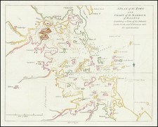
1814 edition of Matthew Carey's map of Massachusetts, from Carey's General Atlas.
The map is hand colored in outline by counties, and shows towns, rivers, lakes, mountains, roads, islands, bays, shoals, and a host of other details.
Carey published the first American Atlas to be published in the United States, compiling a number of excellent maps from indigenous sources in the first compilation of American maps. It is one of the best maps of Massachusetts to appear in a Commercial Atlas in the first half of the Century.
Condition Description
Discoloration at centerfold.
![[Battle of Lexington] Journee de Lexington . . .](https://storage.googleapis.com/raremaps/img/small/94722.jpg)

![[Salem, Massachusetts] Salem Eine Stadt im Engellandischen America, in der Grafschafft Essex, welche von den Engellandern 1629 erbauet worden, und 2 Havfen hat einen fur den Sommer, und einen fur den Winter](https://storage.googleapis.com/raremaps/img/small/70175.jpg)