The item illustrated and described below is sold, but we
have another example in stock. To view the example which
is currently being offered for sale, click the
"View Details" button below.


|
||

|

|
|

|
Stock# 57608
Description
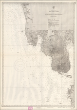
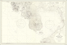
Finely detailed chart showing the approaches to Manila Bay, published by the US Commerce Department.
The map extends to Botolan Point and Mt. Botolan in the northwest and Pamanga Bay, covering all of Subic Bay and the westernmost coastline of Manila Bay.
The southernmost point is Corregidor Island and Mariveles Harbor.
Condition Description
Blue Pencil annotations. Folded.
![S.E. Peninsula and Malaysia [Singapore inset and Pulo Penang or Price of Wales Island inset]](https://storage.googleapis.com/raremaps/img/small/103012.jpg)