|
||

|

|
|

|
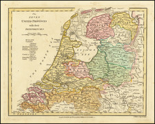
A finely detailed map of the Low Countries, published in Paris.
The map illustrates the united provinces of the Low Countries including Flanders, Brabant, Limburg, Lyege, etc. It also notes archdiocese and bishop's palaces throughout the region.
The map includes an ornate title cartouche along with a scale of miles. It also includes beautifully engraved naval battle scenes and a compass rose within the North Sea (also known as the German Ocean).
Alexis-Hubert Jaillot (ca. 1632-1712) was one of the most important French cartographers of the seventeenth century. Jaillot traveled to Paris with his brother, Simon, in 1657, hoping to take advantage of Louis XIV's call to the artists and scientists of France to settle and work in Paris. Originally a sculptor, he married the daughter of Nicholas Berey, Jeanne Berey, in 1664, and went into partnership with Nicholas Sanson's sons. Beginning in 1669, he re-engraved and often enlarged many of Sanson's maps, filling in the gap left by the destruction of the Blaeu's printing establishment in 1672.
![[ American Revolution - Satirical Warning To Dutch Commerce ] Den Door List en Geweld Aangevallen Leeuw.](https://storage.googleapis.com/raremaps/img/small/99580.jpg)
![Mechlinia [Mechelen]](https://storage.googleapis.com/raremaps/img/small/80595.jpg)
![(France) Gallia Antiqua Ex Aevi Romani Monumentis Eruta et Serenissimi Carnutum Ducis Munificentia Publici Juris Facta [Ancient Gaul From the Roman Age, the erudite Monuments. . .]](https://storage.googleapis.com/raremaps/img/small/82019.jpg)