|
||

|

|
|

|
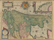
A fine and detailed map of Limburg and Dalem in the southern Netherlands. The map includes a separate sheet with an alphabetical table of towns and villages within Limburg.
Based on the work of Nicholas Sanson, the map highlights the counties and lordships of Faquemont, Rolduc, Salem, Herve, Balen, Sprimont, Monzen, etc, Major cities are colored coded in red including Aachen, Maastricht, Liege, Limburg, etc. The map is embellished with a beautifully engraved title cartouche, scale of distance, a compass, and remarks. Abbeys, chateaus, forts, windmills, and paths are noted throughout the region.
Alexis-Hubert Jaillot (ca. 1632-1712) was one of the most important French cartographers of the seventeenth century. Jaillot traveled to Paris with his brother, Simon, in 1657, hoping to take advantage of Louis XIV's call to the artists and scientists of France to settle and work in Paris. Originally a sculptor, he married the daughter of Nicholas Berey, Jeanne Berey, in 1664, and went into partnership with Nicholas Sanson's sons. Beginning in 1669, he re-engraved and often enlarged many of Sanson's maps, filling in the gap left by the destruction of the Blaeu's printing establishment in 1672.
![[Holy Roman Empire] A Newe Mape of Germany Newly Augmented by Iohn Speed Ano Dom: 1626](https://storage.googleapis.com/raremaps/img/small/67323.jpg)
![[ Rotterdam ] Roterodamum, Hollandiae in ostio Roteri Flu Opp. Magni il:lius Desiderij Erasmi Patria](https://storage.googleapis.com/raremaps/img/small/96869.jpg)
![[ France and Low Countries ] Totius galliae descriptio, cum parte Angliae, Germaniae, Flandriae, Brabantiae, Italiae, Romam usque](https://storage.googleapis.com/raremaps/img/small/74214.jpg)
![[Nymmegen] Novimagium sive Noviromagum vulgo Nijmmegen . . . .](https://storage.googleapis.com/raremaps/img/small/44358.jpg)