![[ Pre-Columbian World Map; ] Secunda etas mundi By Hartmann Schedel](https://storage.googleapis.com/raremaps/img/small/98195.jpg)


|
||

|

|
|

|
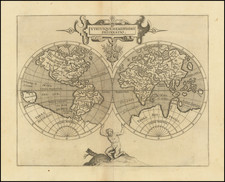
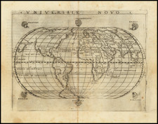
The Old World, From the Famed Nuremberg Chronicle
Striking Ptolemaic-projection world map, one of the earliest obtainable world maps and certainly one of the most visually stunning. This example is from a German edition of the Liber Chronicarum, Schedel’s encyclopedia of Christian history and geography and the most extensively illustrated book of the fifteenth century.
The map shows the oikumene, or the known inhabited world. This was the world based on the geography of Ptolemy in the second century CE and features Europe, Asia, and Northern Africa, with the Indian Ocean shown as an enclosed sea. Of course, when this map was made the world was changing rapidly in terms of what Europeans knew about geography, but news of Columbus’ first voyage to the Americas had not been widely disseminated when this map was first published.
The map is dominated by the mesmerizing ripples of the Atlantic, Mediterranean, and Indian Oceans. There are humped mountain ranges, including two that close off China from the west. The Ganges emerges from six rivers in the interior of Asia.
Another river, the Nile, finds its source in a lake and mountain range in central Africa. These are the Mountains of the Moon. Ptolemy describes such a lakes-and-mountains layout in his works, although the precise identification of the Mountains of the Moon may have been a fourth-century addition to his text. The configuration would survive on maps well into the sixteenth century and beyond, when mapmakers had jettisoned Ptolemy’s coastlines but retained some of his ideas.
A large island in the Indian Ocean is labelled as Taprobana. This is the Greek name for Sri Lanka. The author of The Travels of Sir John Mandeville said that Taprobana was part of the kingdom of Prester John, as well as that the island had mountains of gold guarded by man-eating ants. He went on to explain that the island was the home of the Sciapodes, or men with only one large foot, a detail he borrowed from Greek sources. Such a man is depicted in one of the illustrations on the verso of this map.
Off the coast of West Africa are the Fortunate Isles, a chimeric feature often associated with the wandering island of Hy Brasil. Here, they are roughly in the position of Cape Verde, which the Portuguese discovered in 1456 and began to colonize in 1462. Also shown on this map is a hint of the Gulf of Guinea with a large island. The Portuguese encountered São Tomé and Príncipe in ca. 1470. The map reflects these recent voyages, although it is based on a much older Ptolemaic projection.
The world map is anchored in place by three men, the sons of Noah, Ham, Shem, and Japhet, who re-populated the earth after the Flood. Inside a border are twelve fierce windheads.
To the left are one of the defining features of this particular map, the strip of monstrous humans that supposedly wandered the earth. These are continued from a discussion on the verso, which also has two additional strips. All of these peoples supposedly inhabited the lands outside of Europe; they were the Other to which Europeans could compare themselves.
Hartmann Schedel (1440-1514) was a physician, book collector, and writer whose most famous work, the Liber Chronicarum (Nuremberg Chronicle), included some of the first printed views of many cities in Europe and across the world.
Schedel was born and died in Nuremberg, but he also traveled for his education. From 1456 to 1463 he lived in Leipzig, where he attended the University of Leipzig and earned his MA. From there he went to Padua, where he earned a Doctor of Medicine in 1466. After university, he worked for a time in Nördlingen and then returned to Nuremberg. In 1482 he was elected a member of the Great Council of Nuremberg.
The Chronicle was published in 1493. Besides this major work, one of Schedel’s most enduring legacies is his magnificent manuscript and printed book collection, one of the largest of the fifteenth century. In 1552, Schedel's grandson, Melchior Schedel, sold about 370 manuscripts and 600 printed works from Hartmann Schedel's library to Johann Jakob Fugger. Fugger later sold his library to Duke Albert V of Bavaria in 1571. This library is now mostly preserved in the Bayerische Staasbibliothek in Munich.
Among the surviving portions of Schedel's library are the records for the publication of the Chronicle, including Schedel's contract with Anton Koberger for the publication of the work and the financing of the work by Sebald Schreyer and Sebastian Kammermeister, as well as the contracts with Wohlgemut and Pleydenwurff for the original artworks and engravings. The collection also includes original manuscript copies of the work in Latin and German.
![[Olivier van Noort Portrait / World Map]](https://storage.googleapis.com/raremaps/img/small/79567.jpg)