|
||

|

|
|

|
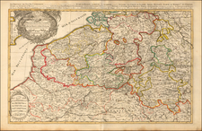
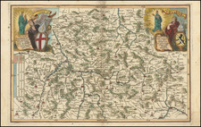
Map of the Duchy of Luxembourg divided into quarters including Walon and German quarters. The map illustrates the provinces, duchies and regions of Brabant, Julier, Marche, Limburg, Luxembourg, Bidbourg, Bouillon, Champagne, Cologne, etc.
Major towns, villages, chateaus, abbeys, churches, and windmills are noted on the map. Major villages are highlighted in red including Liege, Namur, Hildesheim, Gerolstein, Schoneck, Treves, Thionville, Mouzon, Stenay, etc.
A beautifully engraved title cartouche, scale of distance, and symbol chart are included on the map.
Two additional sheets are included with the map. The first sheet is plan of Luxembourg with birds-eye views and maps of Thionville, Montmedy, D'Anuillier, and Arlon. The second sheet includes an alphabetical index of towns and villages within the Duchy of Luxembourg.
Alexis-Hubert Jaillot (ca. 1632-1712) was one of the most important French cartographers of the seventeenth century. Jaillot traveled to Paris with his brother, Simon, in 1657, hoping to take advantage of Louis XIV's call to the artists and scientists of France to settle and work in Paris. Originally a sculptor, he married the daughter of Nicholas Berey, Jeanne Berey, in 1664, and went into partnership with Nicholas Sanson's sons. Beginning in 1669, he re-engraved and often enlarged many of Sanson's maps, filling in the gap left by the destruction of the Blaeu's printing establishment in 1672.