|
||

|

|
|

|
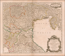
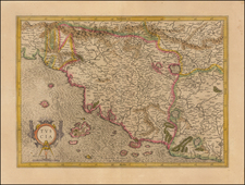
Fine example of Mortier's scarce map of the Territory Vicenza region, published in his Atlas Nouveau.
The map is centered on Vicenza and extends northwest to Trente, southwest to Verona and east to Padova.
The map illustrates the roads in the region and the Routes and Encampments of the French Military, along with the Imperial encampments.
Pierre, or Pieter, Mortier (1661-1711) was a Dutch engraver, son of a French refugee. He was born in Leiden. In 1690 he was granted a privilege to publish French maps in Dutch lands. In 1693 he released the first and accompanying volume of the Neptune Francois. The third followed in 1700. His son, Cornelis (1699-1783), would partner with Johannes Covens I, creating one of the most important map publishing companies of the eighteenth century.
![[Tuscany, Rome, Siena, Pisa, Florence, etc] Status Ecclesiasticus Magnus Ducatus Thoscanae](https://storage.googleapis.com/raremaps/img/small/37120.jpg)