


|
||

|

|
|

|
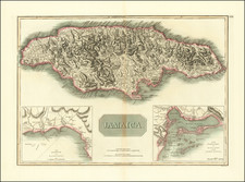
A Rare Early Map of Jamaica
Rare early English map of Jamaica, published in London by John Seller.
The source of Seller's map of John Man's second map. John Man was surveyor general of Jamaica from 1661 to his death sometime around 1671.
The map depicts the most prominent settlements with the landowners named in the large key at bottom. Port Royal is correctly located, and there are numerous settlements shown in the southern portion of the island. Anchorages, rocks, shoals and depth soundings are identified along the coastline.
The map is handsomely embellished with a strapwork title cartouche supporting the coat of arms of Jamaica and putti holding aloft the coats of arms of Governors of the island: Doyley, Winsor, Modiford and Lynch. The large dedication cartouche is left blank, surmounted by Indians and flanked by alligators. Additional decorative elements include a man shooting a bull, a compass rose, a sea monster and a sailing ship.
The map includes a dedicatory cartouche to Jos. Williamson includes Williamson's coat of arms.
John Seller was one of the most notable map and instrument makers in England in the late-seventeenth century. He was especially known for the sea charts, many of which featured in his influential English Pilot and Atlas Maritimus. Seller was born in London in 1632. His father was a cordwainer and John was apprenticed to Edward Lowe, of the Merchant Taylors’ Company. He was made free of that company in 1654. Later, he also was made a brother of the Clockmakers’ Company, which housed several instrument makers. He started business as a compass maker but expanded his offering to include navigational instruments and charts.
Seller’s career was halted temporarily, and fantastically, when he was tried for high treason in 1662. He was accused of involvement in a plot led by Thomas Tonge. While Seller likely only unwisely repeated rumors, he was convicted. The other conspirators, who did admit some degree of guilt, were executed, but Seller maintained his innocence and, via insistent petitions, he eventually secured his release from Newgate Prison.
This episode did not seem to slow Seller’s rise too much, however. Seller was granted a royal license to publish English-language maritime atlases. This gave him a near-monopoly and led to his being named hydrographer to the King in 1671. Although the point of the project was to produce English charts of Dutch dominance and bias, Seller ended up using many Dutch plates as his base material. The first volume of The English Pilot was published in 1671, followed by more volumes as well as The Coating Pilot (1672) and the Atlas Maritimus (1675). Seller was commercially successful, but some of his projects required further support. The English Pilot was eventually taken over by John Thornton and William Fisher, for example, and his proposed English atlas only produced maps of six counties.
Seller’s sons, John and Jeremiah, followed in their father’s profession. Seller also apprenticed several promising young men, including Charles Price, with whom his sons partnered. Through Price, Seller can be seen as the founding figure of an important group of London mapmakers that included Price, John Senex, Emanuel Bowen, Thomas Kitchin, and Thomas Jefferys.
![Amer. Sep. No. 73. Grandes Antilles. [Part of Jamaica]](https://storage.googleapis.com/raremaps/img/small/96296.jpg)
![[War of Jenkins Ear in Florida and West Indies] [Harbors, Towns & Fortresses of North America, St. Augustine, Providence (Grand Bahama Island), Porto Antonio (Jamaica), Havana, Santiago (Cuba), Kingston, and Antiqua)]](https://storage.googleapis.com/raremaps/img/small/75642.jpg)
![Cuba, Jamaica and Porto Rico [Cayman Islands]](https://storage.googleapis.com/raremaps/img/small/78708.jpg)
![Cuba Insula [with] Hispaniola Insula [with] Insula Jamaica [with] Ins. S. Ioannis [with] I.S. Margareta Cum Confiniis](https://storage.googleapis.com/raremaps/img/small/95802.jpg)