|
||

|

|
|

|
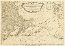
Showing Lake Torrens as an Inland Sea in South Australia
Impressive chart of the Pacific, including Australia and the Americas. It was first published in 1851.
The map includes an early appearance of Hong Kong.
.The chart was compiled by French naval hydrographer Clement Adrien Vincendon-Dumoulin who served aboard two important expeditions to the South Pacific and beyond. Vincendon-Dumoulin accompanied the scientific voyage of 1822-1825 under Duperrey; he also served aboard the second Dumont d'Urville expedition 1837-1840 which sailed well into Antarctic waters. French scientific voyaging of this era aimed to resolve remaining geographical anomalies, and produce accurate hydrographical charting of remote Pacific waters.
Much of the detail of inland Australia is clearly informed by English language exploration accounts.
One curious feature is the size and extent of Lake Torrens in South Australia, here misrepresented as a horseshoe shaped lake on the scale of an inland sea.
Lake Torrens
Approximately 35,000 years ago, the lake water was fresh to brackish, but has become increasingly saline since. The traditional owners of the area are the Arabunna peoples to the north, the Kokatha to the west and the Kyuni to the east. The first European to see the lake was Edward Eyre in 1839 who spotted the salt bed from Mount Arden at the head of the Spencer Gulf. Eyre named the lake after Colonel Robert Torrens who was one of the founders of the South Australian colony.
The Dépôt de la Marine, known more formally as the Dépôt des cartes et plans de la Marine, was the central charting institution of France. The centralization of hydrography in France began in earnest when Jean-Baptiste Colbert became First Minister of France in 1661. Under his watch, the first Royal School of Hydrography began operating, as did the first survey of France’s coasts (1670-1689). In 1680, Colbert consolidated various collections of charts and memoirs into a single assemblage, forming the core of sources for what would become the Dépôt.
The Dépôt itself began as the central deposit of charts for the French Navy. In 1720, the Navy consolidated its collection with those government materials covering the colonies, creating a single large repository of navigation. By 1737, the Dépôt was creating its own original charts and, from 1750, they participated in scientific expeditions to determine the accurate calculation of longitude.
In 1773, the Dépôt received a monopoly over the composition, production, and distribution of navigational materials, solidifying their place as the main producer of geographic knowledge in France. Dépôt-approved charts were distributed to official warehouses in port cities and sold by authorized merchants. The charts were of the highest quality, as many of France’s premier mapmakers worked at the Dépôt in the eighteenth century, including Philippe Bauche, Jacques-Nicolas Bellin, Rigobert Bonne, Jean Nicolas Buache, and Charles-François Beautemps-Beaupré.
The Dépôt continued to operate until 1886, when it became the Naval Hydrographic Service. In 1971, it changed names again, this time to the Naval and Oceanographic Service (SHOM). Although its name has changed, its purpose is largely the same, to provide high quality cartographic and scientific information to the France’s Navy and merchant marine.

![(Malaspina Expedition): [Group of six manuscript documents, signed, related to a future assignment for the officers of the Malaspina expedition, including a voyage to chart the coast of Guatemala and to explore Nicaragua, proposed by the viceroy of New Spain]](https://storage.googleapis.com/raremaps/img/small/101838.jpg)
![Carte Generale de L'Oceanie . . . . 1866 [Pacific Ocean]](https://storage.googleapis.com/raremaps/img/small/99167.jpg)