
This item has been sold, but you can enter your email address to be notified if another example becomes available.


|
||

|

|
|

|
Stock# 5734
Description
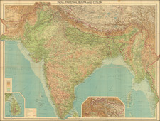
Nice detailed map of India, Ceylon and the Malaysian Peninsula. Shows towns, railroads, rivers, lakes, mountains, railroad lines, sub-oceanic Telegraph lines, etc. Decorative Piano Key border. From Johnston's Handy Royal Atlas, one of the most popular English language atlases of the 2nd half of the 19th Century.

![Asia Secunda Pars Terrae in Forma Pegasi [Asia in the Form of Pegasus]](https://storage.googleapis.com/raremaps/img/small/94173.jpg)