This item has been sold, but you can enter your email address to be notified if another example becomes available.


|
||

|

|
|

|
Stock# 5731
Description
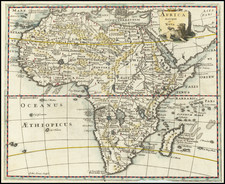
Detailed large format regional map. Shows towns, rivers, roads, railroads, lakes, mountains, islands, bays, points, and many other features. Nice detail in the interior. Includes several exploration routes. Includes sub-Oceanic Telegraphi lines in the Red Sea. Decorative Piano Key border. From Johnston's Handy Royal Atlas, one of the most popular English language atlases of the 2nd half of the 19th Century.
![The West Part of Barbary... [on sheet with:] The East Part of Barbary...](https://storage.googleapis.com/raremaps/img/small/94055.jpg)

![[ Morocco ] Statuum Maroccanorum, Regnorum nempe Fessani, Maroccani, Tafiletanin et Segelomessani Secundum suas Provincias accurate divisorum, Typus generalis novus . . . 1728](https://storage.googleapis.com/raremaps/img/small/95640.jpg)
![[Untitled Map of The Atlantic Ocean, Europe, Africa, the Middle East, and Eastern Canada]](https://storage.googleapis.com/raremaps/img/small/89582.jpg)