This item has been sold, but you can enter your email address to be notified if another example becomes available.


|
||

|

|
|

|
Stock# 5722
Description
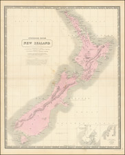
Highly detailed map of the Islands, colored by counties, and showing towns, roads, rives, lakes, mountain, railroad lines, etc. Large inset of the Southern Alps of New Zealand from the Central Moraine of Godley Glacier. The transoceanic telegraph line to Sydney is also shown. A nice large format map. Decorative Piano Key border. From Johnston's Handy Royal Atlas, one of the most popular English language atlases of the 2nd half of the 19th Century.