This item has been sold, but you can enter your email address to be notified if another example becomes available.


|
||

|

|
|

|
Stock# 57084
Description
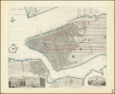
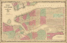
Detailed Transit map of Manhattan Island (south of 96th Street) and adjacent cross-river districts.
The map shows Manhattan from Battery Park to 96th Street, along with parts of New Jersey, Brooklyn, and Queens.
The map illustrates the ferry and rail lines in and out of Manhattan, and the elevated, cable, and cross town car lines on the Island.
The Brooklyn Bridge is called 'Suspension Bridge'. Major landmarks shown include:
- Washington Square
- Union Square
- Bryant Square
- Central Park
- Grand Central Depot
- Ellis Island
- Governor's Island
- Bedloe's Island (Liberty Island)
Condition Description
Folding map with promotional text on verso.