The item illustrated and described below is sold, but we
have another example in stock. To view the example which
is currently being offered for sale, click the
"View Details" button below.


|
||

|

|
|

|
Stock# 57063
Description
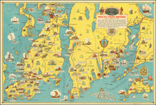
Decorative pictorial map showing the lower part of Rhode Island and Massachusetts, from Newport to Martha's Vineyard and part of Cape Cod.
On the verso is "Newport's Famous Ten Mile Drive Along the Ocean Front showing the locations of the beautiful summer residences of many prominent people" with vignette illustrations depicting the houses and naming the owners. A fascinating bit of local history.
Two other smaller maps show roads of Connecticut, Massachusetts and Rhode Island and a map of the area around the Mount Hope Bridge.
![[Kensington Metropolitan Park / Kent Lake] Scouting To Adventure Gold Rush of '48 Detroit Area Council Boy Scouts of America . . . 1948](https://storage.googleapis.com/raremaps/img/small/63032.jpg)