The item illustrated and described below is sold, but we
have another example in stock. To view the example which
is currently being offered for sale, click the
"View Details" button below.


|
||

|

|
|

|
Stock# 57014
Description
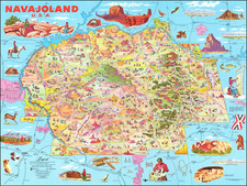
Scarce Don Bloodgood pictorial map of the Navajo Nation, published for the Navajo Tribal Council.
The map depicts the Navajo Lands of Northeastern Arizona and bounded in the west by the Little Colorado River, Grand Canyon, Flagstaff and Lake Powell to Shiprock and Gallup, New Mexico.
Lots of mining lands, trading posts and western topography, overlaid with a whimsical touristy pictorial style characteristic of Bloodgood's work.
The map provides a remarkable and colorful image of the region.
![[ Downtown St. Helena ] Mattioli's in your Pocket Guide St. Helena -- 13th Annual Edition [ Napa Valley, CA ]](https://storage.googleapis.com/raremaps/img/small/102768.jpg)